Waste Site Surveying
Drone Landfill Survey Service
High-precision drone surveys for landfill volume computations, void space assessment, and regulatory compliance monitoring across UK waste management facilities.
Avg Response within 5 Mins • Or phone +44 1334 804554
Understanding Drone Landfill Surveys
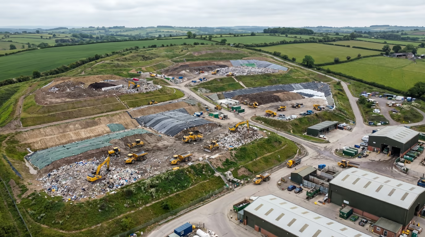
A UAV landfill survey employs sophisticated drone technology to acquire precise survey data from waste management facilities, enabling accurate volume computations, capacity tracking, and regulatory compliance documentation. Our UAVs gather thousands of data points across your site within minutes, generating detailed 3D models that reveal the actual configuration and volume of your landfill cells.
At Hire Drone Pilot, we focus on landfill surveying for waste management operators, environmental consultants, and local authorities throughout the UK. Our surveys deliver the precise, defensible data you require for environmental permits, void space computations, and operational planning—all captured safely without interrupting active tipping operations.

Peter Leslie
Owner & Drone Pilot
"Have questions? Ring me directly - I'm happy to discuss your project requirements."
Call NowPrecise Landfill Volume Data,Rapid Delivery
What You'll Receive
- Precise volume computations
- Void space & capacity assessment
- Progress monitoring reports
- Survey-grade precision (±2-5cm)
Delivered in 5-7 working days
Why Use HireDronePilot
- CAA certified & comprehensively insured
- Landfill survey sector experts
- Advanced DJI & RTK equipment
- Nationwide availability
Relied upon by waste management operators and environmental consultants throughout Britain.
Relied upon by industry leaders
What's the Investment for Drone Landfill Surveys?
Costs vary based on site dimensions and specifications. Here's a pricing overview to assist your planning:
| Project Scale | Starting From |
|---|---|
| Individual Cell1 landfill cell | £600+ |
| Compact Site2-5 cells | £1,000+ |
| Mid-Size Site5-15 cells | £1,800+ |
| Extensive Site15+ cells | £3,000+ |
| Scheduled MonthlyOngoing monitoring | POA |
*Indicative prices cover standard outputs. Final quotation reflects site complexity, accessibility, and particular needs.
Factors influencing your quotation?
- Cell quantity
- Site complexity
- Specific output needs
- Survey regularity
Our UAV-based approach generally achieves 50-70% cost savings versus conventional ground surveys of landfill sites. Get in touch with your project specifics and we'll supply a customised quotation within 24 hours.
Prepared to receive pricing for your landfill survey?
Complimentary, obligation-free quotes within 24 hours
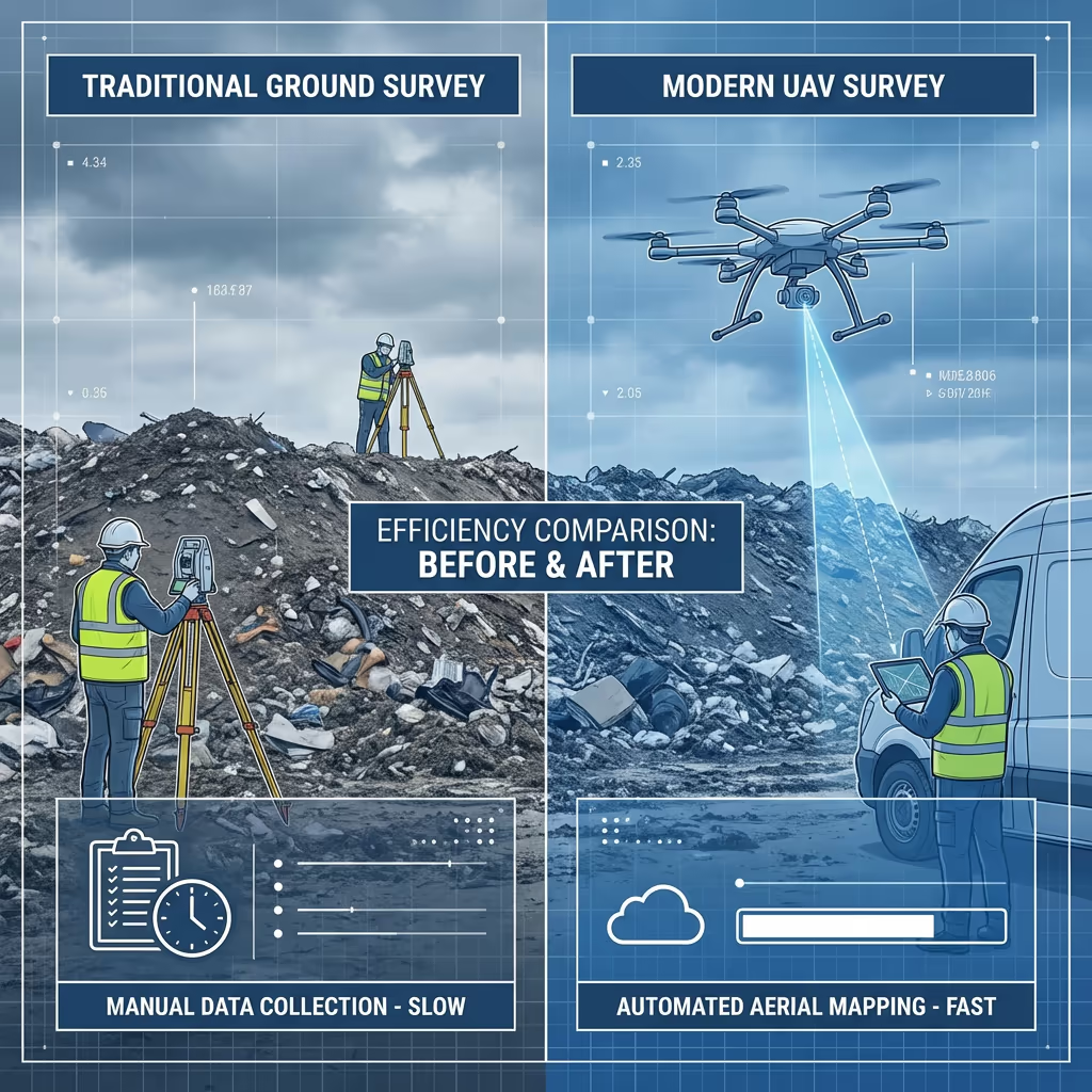
How Do Drone Landfill Surveys Compare to Conventional Approaches?
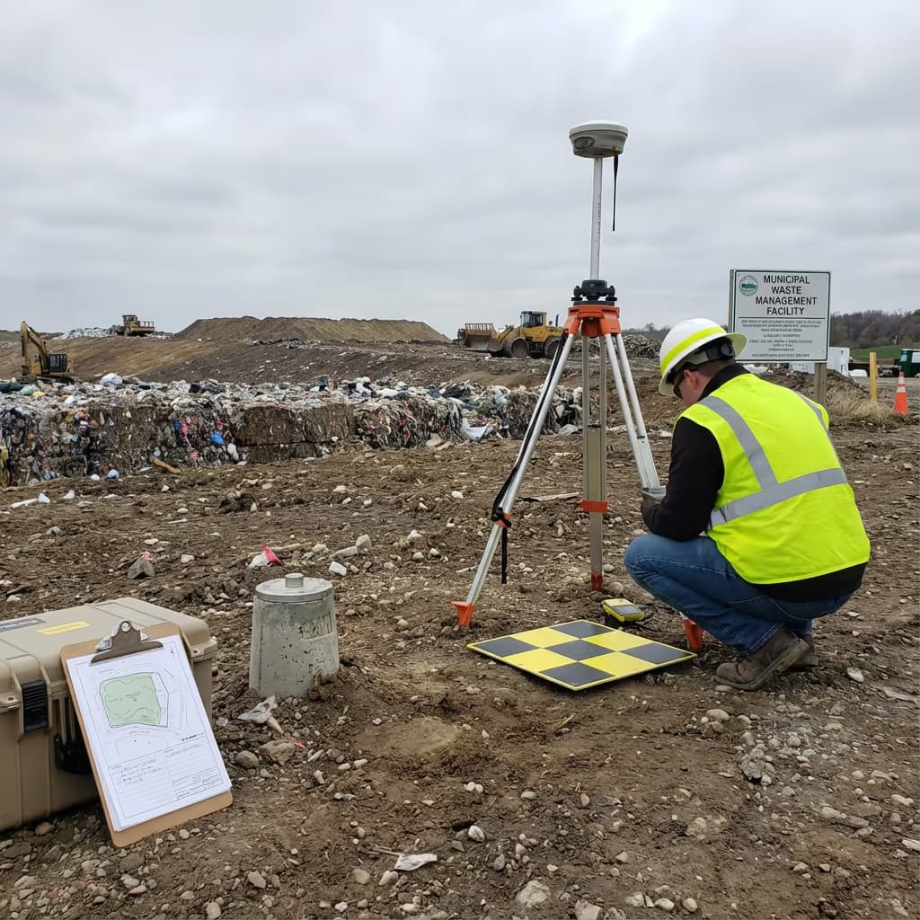
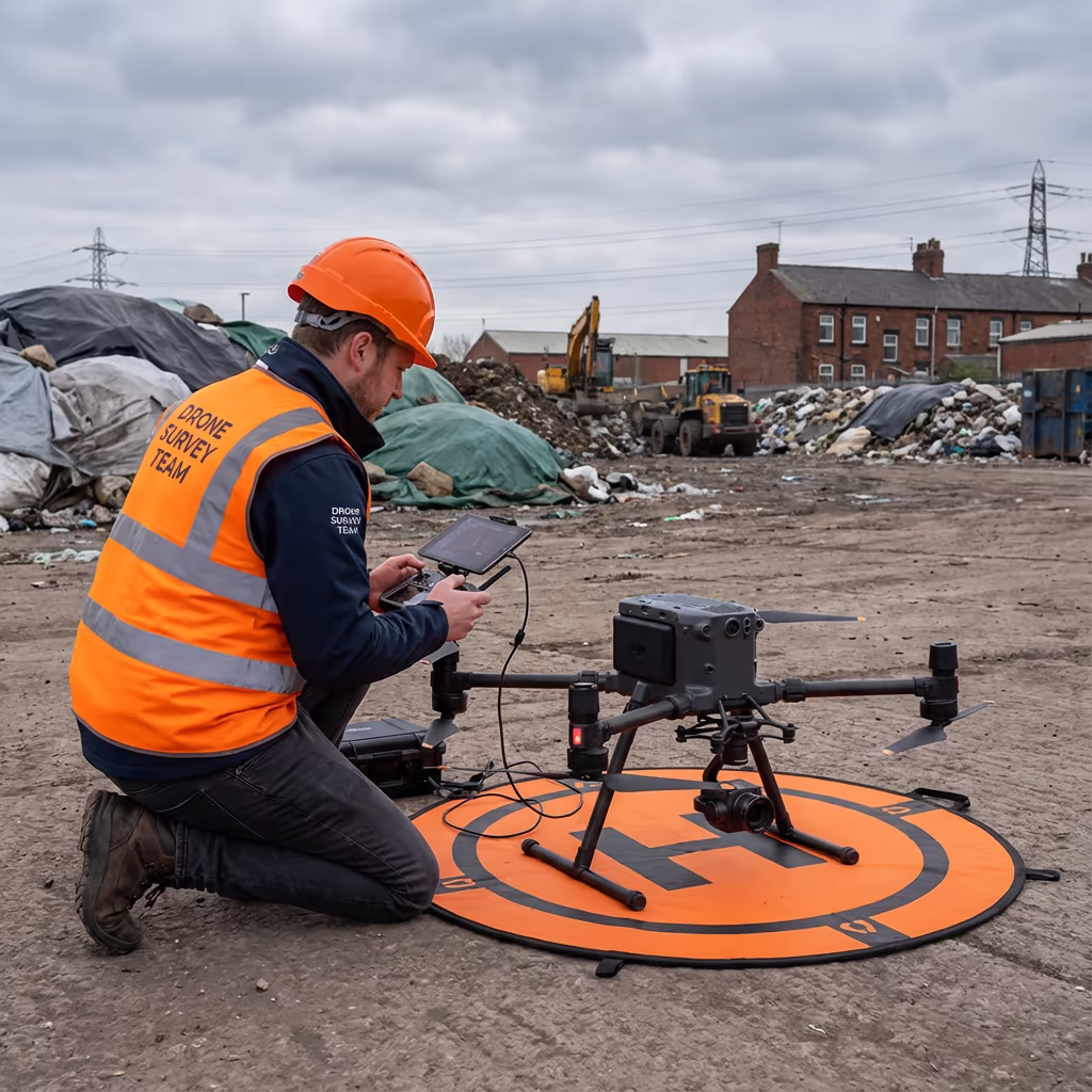
Conventional landfill surveys demand that surveyors traverse active tipping zones, capturing measurements using total stations or GPS instruments. This proves slow, costly, and frequently hazardous on unstable waste surfaces. Ground teams also struggle to document detail in areas with operational machinery activity.
UAV landfill surveys acquire comprehensive data from altitude, removing safety hazards and dramatically shortening survey duration. Our drones execute autonomous missions across your site, gathering thousands of georeferenced images that we transform into precise 3D models and volume computations—all without stepping onto the waste surface.
Selecting the Optimal Method
Opt for UAV Survey
Swift, secure & thorough
Opt for Conventional
Precise detail necessary
Uncertain which method fits your site?
What Precision Levels Do Drone Landfill Surveys Attain?
Our UAV landfill surveys consistently deliver vertical precision of ±2-5cm and horizontal precision of ±3-5cm when utilising ground control points. This accuracy standard surpasses requirements for environmental permit documentation and supplies reliable data for void space computations and capacity planning.
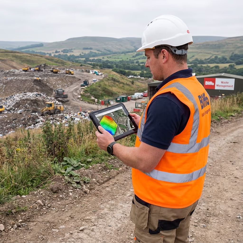
We deploy RTK-enabled drones featuring integrated GNSS positioning, augmented by strategically positioned ground control points surrounding your site. This approach guarantees consistent precision across the complete survey area, irrespective of cell activity or terrain variations. The outcome is volume computations you can confidently submit to regulators and utilise for operational decisions.
Where Are Drone Landfill Surveys Applied?
UAV landfill surveys support waste management operations throughout the complete site lifecycle. These are the primary applications where our clients experience the most significant benefits:
Volume Quantification
Precise computation of deposited waste volumes, monitoring fill rates and comparing against permit allocations.
Capacity Tracking
Continuous measurement of remaining void space informing operational planning and permit submissions.
Regulatory Adherence
Supplying precise survey data for Environment Agency reporting, permit amendments, and compliance documentation.
Progress Documentation
Scheduled surveys monitoring cell advancement, comparing against engineering plans, and documenting construction stages.
Restoration Tracking
Monitoring capping and restoration activities, confirming profiles against design specifications and settlement observation.
Due Diligence Assessment
Independent survey data supporting site acquisitions, valuations, and verification of documented volumes and remaining capacity.
Got a landfill requiring survey work?
Can UAVs Determine Remaining Landfill Capacity?
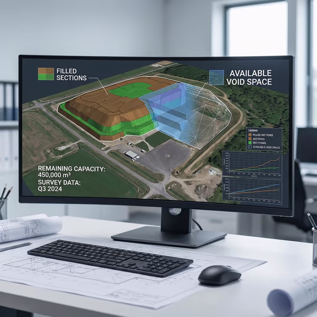
Yes—this represents one of the most valuable uses of UAV landfill surveys. By comparing our precise 3D surface models against your permitted final contours or engineering designs, we compute exactly how much void space remains within each cell. This void space assessment proves essential for planning tipping operations, projecting site lifespan, and supporting permit submissions.
We can additionally track how capacity evolves over time through scheduled monitoring surveys. This provides you with reliable data for business planning, assists in optimising cell usage, and supplies the documentation regulators demand. Our reports clearly display remaining capacity in cubic metres, simplifying communication with stakeholders and planning for future developments.
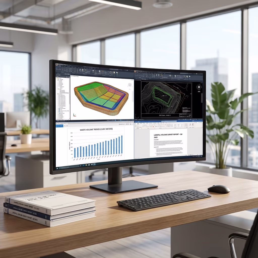
What Outputs Do You Receive From a Drone Landfill Survey?
We customise outputs to match your particular requirements, though our standard UAV landfill survey deliverables encompass:
Volume Computations
Precise volume reports displaying total waste deposited, variations since earlier surveys, and remaining capacity within each cell.
Void Space Assessment
Comprehensive reports displaying remaining permitted capacity, comparison against design profiles, and projected site lifespan computations.
Progress Monitoring Reports
Visual and numerical comparison across survey dates, displaying fill rates, settlement, and operational advancement over time.
Regulatory Documentation
Documentation structured for Environment Agency submissions, permit adherence, and annual returns.
CAD Files & Three-Dimensional Models
Digital surface models, contours, and CAD-compatible files supporting AutoCAD, Civil 3D, and additional engineering software.
Require particular outputs for your project?
What's the Duration of a Drone Landfill Survey?
On-site data acquisition is exceptionally rapid compared to conventional approaches. A standard landfill site containing 5-10 cells can be surveyed within 2-4 hours of flight time, plus setup and ground control point deployment. Larger sites may necessitate a complete day on-site.
Processing and delivery varies according to project complexity and your specified outputs. Standard deliverables including volume computations and reports are typically prepared within 5-7 working days. For pressing requirements, we provide expedited processing with 48-72 hour turnaround available at supplementary cost.
| Stage | Timeframe |
|---|---|
| Planning & Organisation | 1-2 days |
| On-Site Data Acquisition | ½-1 day |
| Data Processing | 2-3 days |
| Volume Assessment | 1-2 days |
| Output Generation | 1-2 days |
| Overall (Standard) | 5-7 working days |
Expedited Processing Offered
Require faster delivery? 48-72 hour turnaround accessible for pressing projects.

How Should I Select a Drone Landfill Survey Provider?
Not every UAV survey provider grasps the unique demands of waste management facilities. When assessing providers for your landfill survey, we suggest verifying these essential criteria:
- CAA certification – Confirm they possess valid GVC or legacy PfCO authorisations for commercial work
- Landfill expertise – Waste facilities present distinct challenges; seek demonstrated sector experience
- Comprehensive insurance – Public liability and professional indemnity coverage suited to waste site operations
- Volume computation proficiency – Enquire about their approach to volume and void space assessment
- Health & safety adherence – Knowledge of waste site H&S protocols and induction processes
At Hire Drone Pilot, we satisfy every criterion. We're CAA certified, comprehensively insured, and have completed landfill surveys for waste management operators and environmental consultants across Britain. We comprehend the regulatory demands and can supply data in the formats your permits necessitate.
Prepared to partner with a dependable landfill survey provider?
Are Drone Landfill Surveys More Cost-Effective Than Conventional Approaches?
In nearly every situation, yes—substantially. Conventional ground surveys of operational landfill facilities are time-consuming, expensive, and present considerable health and safety hazards. Surveyors operating on unstable waste surfaces require extensive safety protocols, and the time needed to manually gather data across expansive cells causes costs to escalate rapidly.
Our UAV surveys capture thorough, precise data in a fraction of the time with zero personnel on the waste surface. The cost reductions typically span 50-70% compared to conventional approaches, whilst also providing quicker turnaround and more comprehensive datasets. For facilities requiring periodic monitoring, the economics become even more advantageous with recurring survey arrangements.
Prepared to Talk About Your Landfill Survey Project?
Professional guidance • Customised pricing • Avg Response within 5 Mins

Peter Leslie
Owner & Drone Pilot
Bringing considerable expertise in surveying and UAV operations, Peter personally manages every landfill survey project to guarantee precise volume data and professional delivery.
Quick Reference: UAV Landfill Surveys Explained
Landfill Survey Outputs
- Volume computations
- Void space assessment
- Progress monitoring reports
- Regulatory adherence reports
- CAD files (DWG/DXF)
- 3D surface models
Talk About Your Project
Receive professional guidance and customised pricing.
Drone Pilot Reviews
Why Drone Pilots Rate HireDronePilot 5 Stars
Don't just take our word for it. Here's what drone pilots in our UK network say about getting work through the platform.
“I get relevant commercial briefs with clear scopes, so quoting is fast and accurate. It has helped me win consistent survey work without chasing low-quality leads.”
Adam Carter
Drone Pilot
“Since joining the platform, I have filled gaps in my schedule with quality roof and inspection jobs. The enquiry details are much better than generic lead forms.”
Sophie Bennett
Drone Pilot
“HireDronePilot makes it easier to focus on delivery. I can review project briefs quickly, submit competitive quotes, and pick up work in new regions.”
Daniel Khan
Drone Pilot
Complementary Services
Drone Survey
Thorough UAV surveys providing precise topographic data and three-dimensional models.
Volumetric Assessment
Precise stockpile quantification and cut/fill computations from drone data.
UAV Topographic Survey
Comprehensive topographic surveys for planning, design, and construction initiatives.