Surveying & Mapping
Drone Volumetric Survey Service
Accurate stockpile quantification and material calculations through advanced UAV technology. Quicker, safer, and more reliable than conventional approaches.
Avg Response within 5 Mins • Or phone +44 1334 804554
Understanding Drone Volumetric Surveys
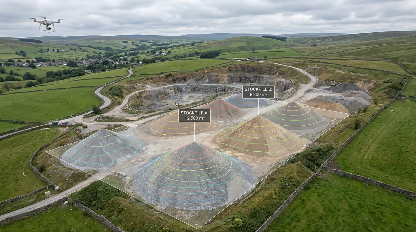
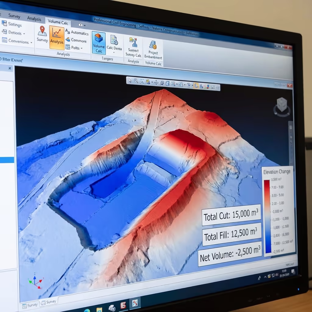
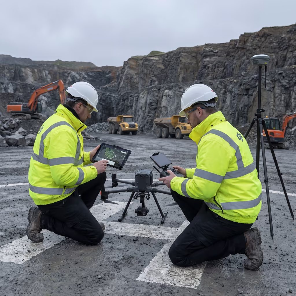
A UAV volumetric survey employs drone photogrammetry to determine the exact volume of material stockpiles, excavations, and earthworks. Our drones photograph hundreds of overlapping frames that transform into comprehensive 3D models, enabling automatic extraction of precise volume data.
Hire Drone Pilot provides volumetric surveys achieving 1-3% accuracy—frequently surpassing the precision of conventional ground-based techniques. Whether you need aggregate stockpile measurements at a quarry, earthworks monitoring on a construction project, or material inventory verification, our UAV surveys deliver the information you require swiftly and without risk.

Peter Leslie
Owner & Drone Pilot
"Have questions? Ring me directly - I'm happy to discuss your project requirements."
Call NowPrecise Volume Data,Rapid Turnaround
What You'll Receive
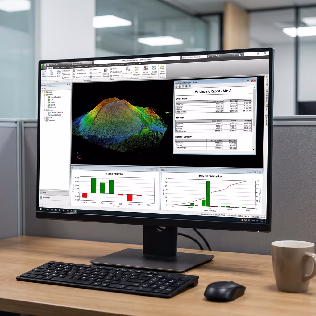
- Certified volume documentation (PDF)
- Cut/fill analysis with colour visualisations
- 3D stockpile models (OBJ/mesh)
- 1-3% measurement accuracy
Complete within 3-5 working days
Why Use HireDronePilot
- CAA certified & comprehensively insured
- Dedicated volumetric processing expertise
- Latest DJI survey equipment
- Nationwide coverage
Relied upon by quarries, building contractors & material suppliers throughout the UK.
Chosen by industry leaders
Drone Volumetric Survey Pricing Guide
Costs vary based on stockpile quantity and site requirements. Use this guide for budget planning:
| Project Scale | Indicative Cost |
|---|---|
| Single Stockpile1 pile | £400+ |
| Small Site2-5 piles | £600+ |
| Medium Site5-10 piles | £900+ |
| Large Site10-20 piles | £1,400+ |
| Recurring MonthlyRegular surveys | POA |
| EnterpriseMulti-site | POA |
*Indicative prices cover standard outputs. Final quotation depends on site accessibility, stockpile dimensions, and particular needs.
Factors influencing your quotation
- Stockpile count
- Site accessibility & safety
- Required turnaround
- Survey frequency
Our UAV volumetric surveys typically cost 50-70% less than conventional surveying approaches while producing results in a fraction of the time. Share your requirements with us and receive a customised quotation within 24 hours.
Prepared to receive a project quotation?
Complimentary, no-commitment quotes within 24 hours
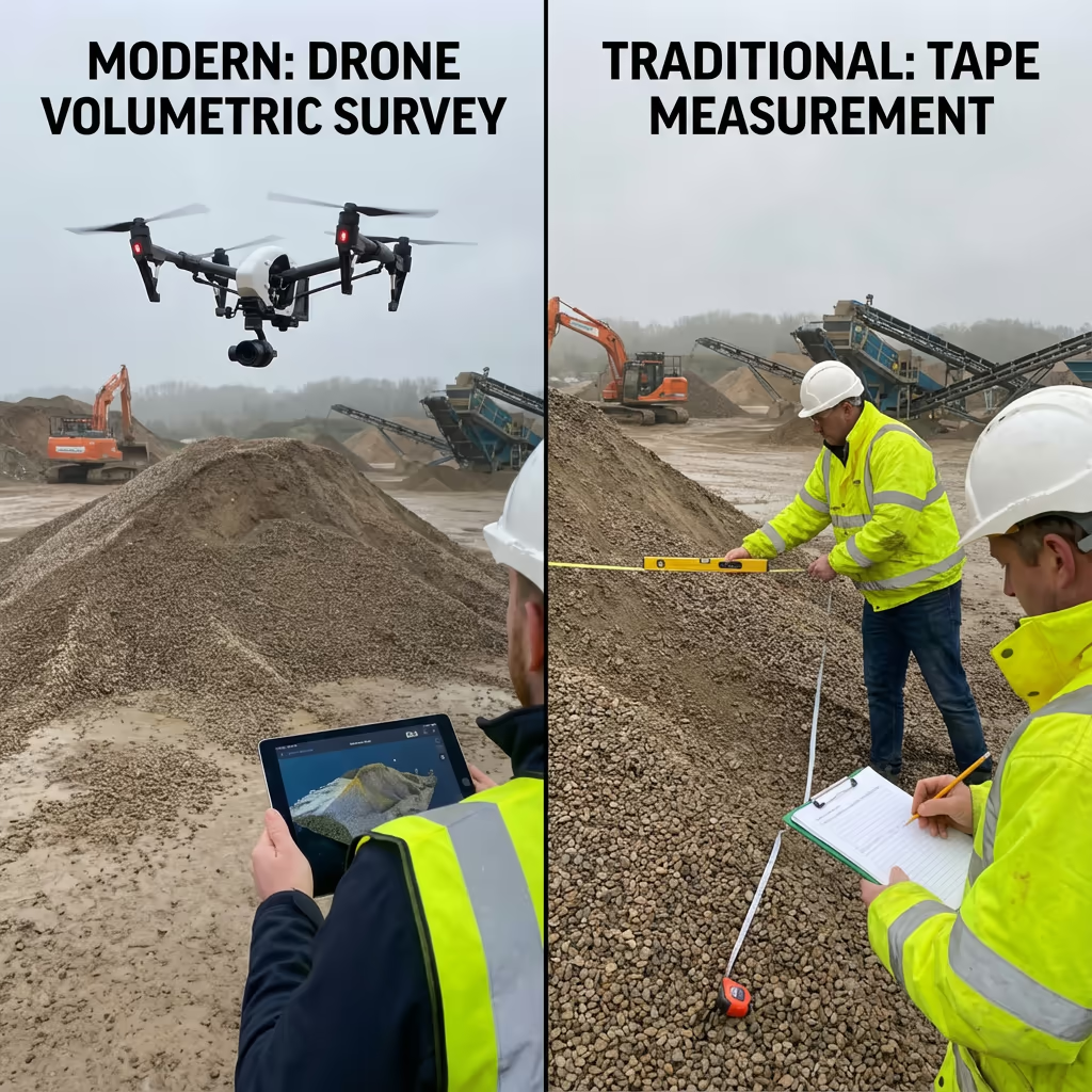
Drone Volumetric Survey vs Conventional Measurement Methods
Conventional stockpile measurement depends on physical tape readings, GPS surveys with rod measurements, or wheel-based techniques. Surveyors must physically traverse around and across stockpiles—a labour-intensive process that introduces safety hazards and frequently overlooks irregular contours and surface variations.
UAV volumetric surveys record thousands of surface points without personnel setting foot on the stockpile. Our drone methodology generates comprehensive 3D models capturing every undulation, gradient, and irregularity. This delivers swifter data acquisition, enhanced safety, and measurements typically surpassing ground-based methods in accuracy.
Side-by-Side Overview
UAV Volumetric Survey
Contemporary method
Conventional Methods
Ground-level approach
Curious about potential savings?
Precision Levels in Drone Volumetric Surveys
Our UAV volumetric surveys reliably achieve 1-3% accuracy for volume calculations. This precision level satisfies or surpasses requirements for stock management, financial documentation, and regulatory adherence throughout the aggregates and mining sectors.
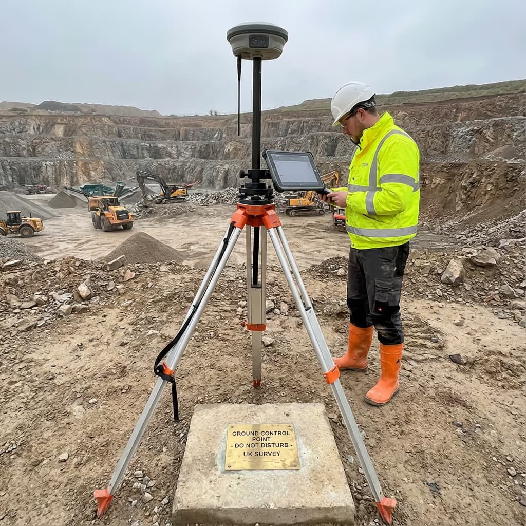
We attain this precision using RTK/PPK-equipped drones, strategically positioned ground control points, and meticulous processing protocols. Every survey undergoes quality verification against known volumes and control markers prior to delivery. For clients demanding maximum precision, we can deploy enhanced ground control networks to achieve accuracy below 1%.
Industry Uses for Drone Volumetric Surveys
UAV volumetric surveys benefit numerous industries where precise volume measurement proves essential for operations, compliance, or financial documentation:
Quarries & Mining Operations
Stock auditing, extraction monitoring, reserve estimations, and royalty confirmation for aggregates, sand, gravel, and mineral sites.
Construction Projects
Cut/fill computations, earthworks progress tracking, material monitoring, and contractor validation for civil engineering schemes.
Waste & Recycling Facilities
Landfill capacity assessment, waste volume monitoring, regulatory compliance documentation, and void space determination.
Ports & Logistics Hubs
Bulk cargo quantification, coal and ore stockpiles, inventory oversight, and shipping confirmation.
Agricultural Operations
Silage pits, grain storage, fertiliser stockpiles, and crop residue volumes for farm administration.
Material Supply Yards
Building merchants, concrete plants, and material depots needing periodic stock reviews and inventory confirmation.
Require precise volume data?
Reliability of Drone Volume Measurements
Drone volumetric measurements deliver exceptional accuracy—typically within 1-3% of true volumes. This precision stems from combining high-resolution photogrammetry, exact GPS positioning, and advanced 3D modelling software that captures the authentic surface profile of every stockpile.
Independent research confirms drone surveys consistently surpass conventional tape and GPS rod techniques, which typically manage only 5-15% accuracy. The decisive advantage lies in coverage: whilst traditional methods sample limited points, drone surveys capture millions of surface coordinates defining the complete geometry of each stockpile.
Precision Benchmarks
1-3%
UAV Survey
5-10%
GPS Rod
10-15%
Tape Measure
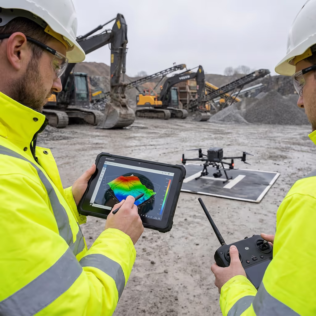
Outputs From Your Drone Volumetric Survey
We customise outputs to match your needs, though our standard volumetric survey package comprises:
Volume Documentation (PDF)
Certified volume computations for each stockpile featuring methodology, accuracy declarations, and summary tables prepared for auditing.
Cut/Fill Assessment
Colour-graded maps displaying volume variations between surveys. Vital for monitoring earthworks advancement and material transfer.
3D Stockpile Reconstructions
Comprehensive mesh models (OBJ format) viewable in standard 3D applications or integrated into your management platforms.
Orthomosaic Imagery
High-definition drone photography of your site, georeferenced and compatible with GIS applications or basic visual assessment.
Reconciliation Analysis
Material flow assessment comparing surveyed volumes against sales/dispatch records to highlight variances.
Require particular outputs for your project?
Drone Volumetric Survey Timeframes
Field data acquisition is impressively swift. A standard site containing 5-10 stockpiles can be surveyed within 1-2 hours, including preparation and ground control setup. Even extensive quarries with 20+ stockpiles seldom require more than half a day.
Processing and delivery timescales depend on project complexity. Standard volume documentation is typically prepared within 3-5 working days. For time-sensitive requirements, we provide express processing with 24-48 hour delivery available at supplementary cost.
| Stage | Timeframe |
|---|---|
| Planning & Scheduling | 1-2 days |
| Field Survey | 1-4 hours |
| Data Processing | 1-2 days |
| Volume Computation | 1 day |
| Report Preparation | 1 day |
| Total (Standard) | 3-5 working days |
Expedited Processing Offered
Require faster delivery? 24-48 hour turnaround offered for time-critical projects.
Selecting Your Drone Volumetric Survey Partner
Not every drone survey company possesses the expertise for precise volumetric work. When assessing providers, verify these essential criteria:
- CAA certification – Confirm they maintain valid GVC or legacy PfCO permits for commercial work
- Comprehensive insurance – Public liability and professional indemnity coverage suited to your sector
- Volumetric expertise – Enquire directly about stockpile measurement precision and techniques
- RTK/PPK technology – Critical for attaining accuracy standards needed for financial documentation
- Sector references – Seek testimonials from comparable operations within your industry
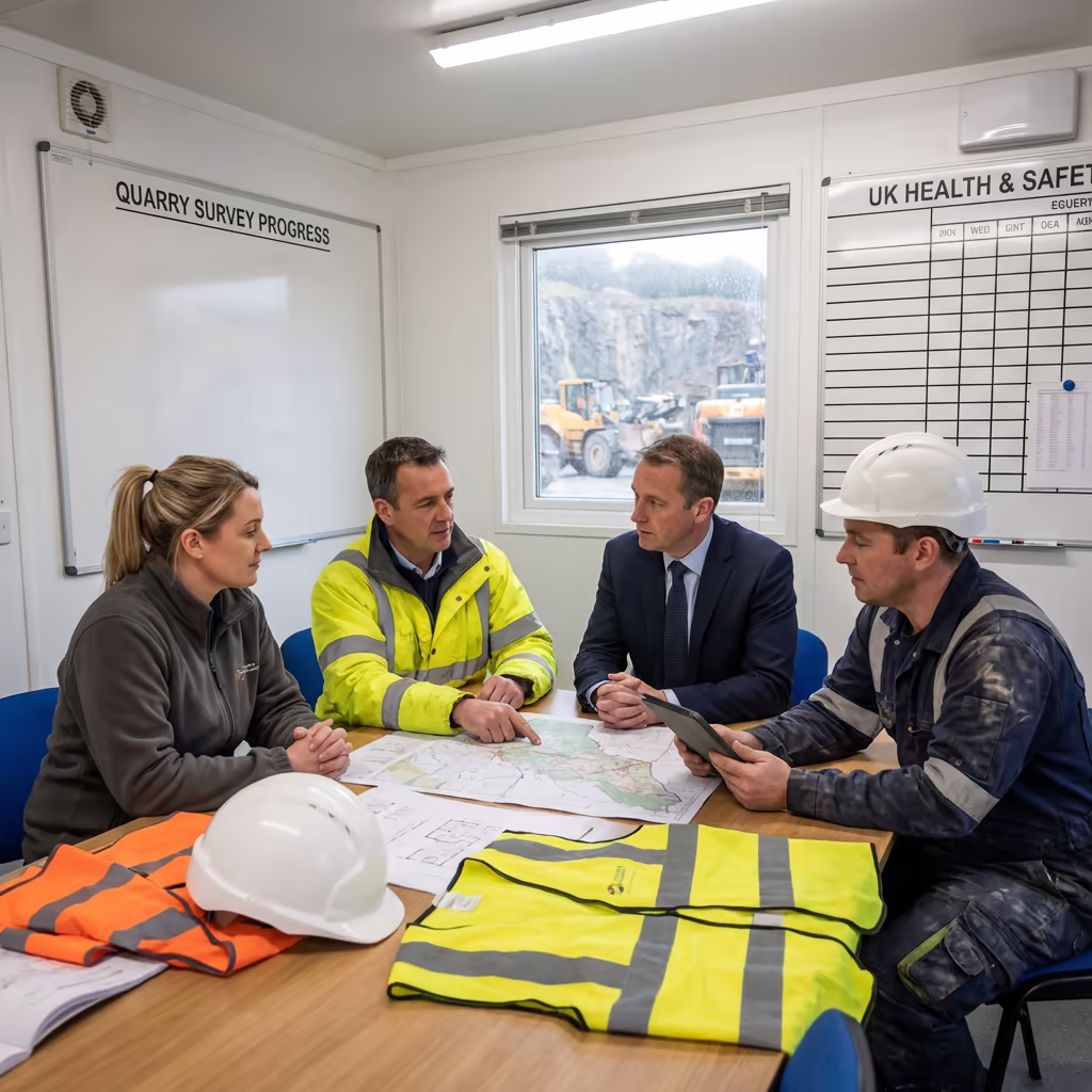
Hire Drone Pilot meets every criterion. We hold CAA approval, carry full insurance, and have completed volumetric surveys for quarries, construction sites, and material suppliers across the UK. Our RTK-equipped technology and stringent processing protocols guarantee the precision your business relies upon.
Prepared to partner with a reliable volumetric survey specialist?
Drone Volumetric Survey Cost Advantages Over Traditional Methods
Yes—considerably so in most situations. Conventional volumetric surveys demand surveyors physically measure stockpiles using tape measures, GPS rovers, or laser instruments. This proves time-consuming, resource-intensive, and frequently necessitates multiple site visits for expansive yards.
Our UAV surveys capture equivalent data in a fraction of the time. A site requiring a ground team an entire day can be surveyed within hours. Cost reductions typically reach 50-70% versus traditional approaches, whilst providing swifter delivery and frequently superior accuracy. For ongoing surveys, the value proposition strengthens further with our monthly arrangements.
Prepared to Explore Your Volumetric Survey Needs?
Professional guidance • Customised pricing • Avg Response within 5 Mins

Peter Leslie
Owner & Drone Pilot
Bringing substantial expertise in surveying and UAV operations, Peter directly supervises every volumetric project ensuring measurement precision and professional completion.
Quick Guide: UAV Volumetric Surveys
Survey Outputs
- Volume documentation (PDF)
- Cut/fill assessment
- 3D stockpile reconstructions
- Change monitoring
- Orthomosaic imagery
- Reconciliation analysis
Talk About Your Project
Receive professional guidance and bespoke pricing.
Drone Pilot Reviews
Why Drone Pilots Rate HireDronePilot 5 Stars
Don't just take our word for it. Here's what drone pilots in our UK network say about getting work through the platform.
“I get relevant commercial briefs with clear scopes, so quoting is fast and accurate. It has helped me win consistent survey work without chasing low-quality leads.”
Adam Carter
Drone Pilot
“Since joining the platform, I have filled gaps in my schedule with quality roof and inspection jobs. The enquiry details are much better than generic lead forms.”
Sophie Bennett
Drone Pilot
“HireDronePilot makes it easier to focus on delivery. I can review project briefs quickly, submit competitive quotes, and pick up work in new regions.”
Daniel Khan
Drone Pilot
Connected Services
Drone Survey
Thorough drone surveys producing accurate topographic information and 3D representations.
Topographic Mapping
In-depth topographic surveys supporting planning, design and construction endeavours.
LiDAR Surveying
High-precision LiDAR scanning for terrain modelling and vegetation canopy penetration.