Environmental & Land
Drone Quarry Survey
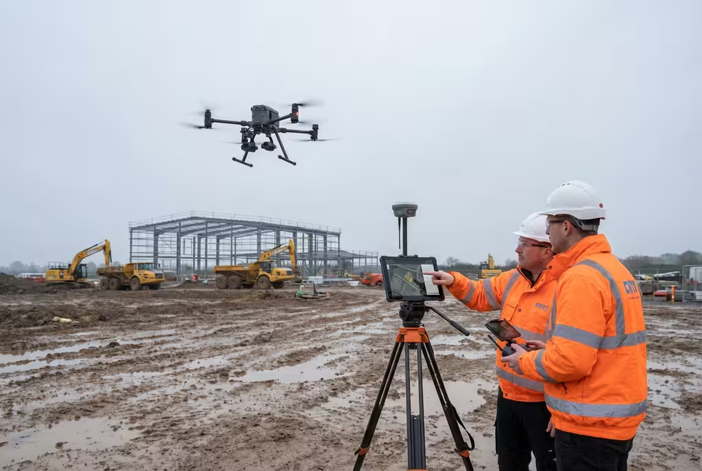
Accurate stockpile volumes, comprehensive pit mapping, and extraction monitoring delivered safely from above. Eliminate the risks of manual measurements in active quarry environments.
Avg Response within 5 Mins • Or call +44 1334 804554
What Is a Drone Quarry Survey?
A drone quarry survey uses unmanned aerial vehicles to capture detailed aerial imagery and elevation data across quarry operations. The data is processed using photogrammetry to produce accurate 3D models, orthomosaic maps, and digital terrain surfaces from which stockpile volumes, pit depths, and site topography can be precisely calculated.
At Hire Drone Pilot, we provide regular and one-off drone surveys for quarries, aggregate operations, and mineral extraction sites throughout the UK. Our surveys deliver the volumetric data, progress mapping, and compliance documentation that quarry managers need—without requiring personnel to enter hazardous working areas or halt operations during measurement.
Peter Leslie
Owner & Drone Pilot
"Have questions? Ring me directly - I'm happy to discuss your project requirements."
Call NowAccurate Volumes,Zero Operational Downtime
What You'll Receive
- Stockpile volume calculations
- Full quarry orthomosaic mapping
- Digital terrain models & contours
- Extraction progress reports
Delivered in 3-5 working days
Why Use HireDronePilot
- CAA certified & fully insured
- No halt to quarry operations
- Accuracy within 1-2% of true volume
- Nationwide UK coverage
Trusted by quarry operators, mineral planners & aggregate companies across the UK.
Trusted by leading organisations
How Much Does a Drone Quarry Survey Cost?
Quarry survey pricing depends on the site area, number of stockpiles, and whether you require one-off or ongoing monitoring. Here is a guide to assist with budgeting:
| Survey Scope | Guide Price |
|---|---|
| Single StockpileIndividual pile measurement | £350+ |
| Full Quarry SurveyComplete site mapping | £800+ |
| Monitoring PackageQuarterly surveys | £2,500+/yr |
| Large/Multi-SiteMultiple quarries | POA |
| GCP Survey Control | +£200 |
*Guide prices include standard deliverables. Final quotation depends on quarry size, stockpile count, and specific requirements.
Factors Influencing Your Quote
- Quarry area & pit depth
- Number of stockpiles
- Survey frequency required
- Reporting & compliance needs
Compared to traditional surveying methods using GPS rovers and ground teams in active quarry environments, drone surveys typically save 50-70% on costs while delivering results far more quickly and safely. Send us your site details and we will provide a tailored quotation within 24 hours.
Ready to receive a quote for your quarry survey?
Free, no-obligation quotes within 24 hours
How Do Drone Quarry Surveys Compare to Traditional Methods?
Traditional quarry stockpile measurement relies on survey teams walking across stockpiles with GPS rovers, taking spot measurements and interpolating between points. This is slow and carries significant health and safety risks. A drone quarry survey captures the entire site from above in a fraction of the time, generating millions of measurement points. Stockpile volumes calculated from drone data are typically within 1-2% of true values—often more accurate than ground-based methods relying on interpolation.
Why Choose Drone Over Traditional?
Drone Quarry Survey
Safe, fast & highly accurate
Traditional Survey
Ground crews & GPS rovers
Not sure which approach suits your quarry?
What Accuracy Can a Drone Quarry Survey Achieve?
With properly established ground control points, our drone quarry surveys achieve horizontal accuracy of 1-2cm and vertical accuracy of 2-3cm. This translates to stockpile volume accuracy typically within 1-2% of true volumes. The dense point cloud generated from drone imagery contains millions of surface measurements compared to the hundreds captured by a ground team, meaning the surface model more faithfully represents actual stockpile geometry and reduces interpolation errors that cause significant volume miscalculations in traditional methods.
Where Are Drone Quarry Surveys Used?
Drone quarry surveys serve a wide range of operational and regulatory requirements. Here are the primary applications where our clients derive the greatest value:
Stockpile Volumes
Accurate measurement of aggregate, sand, gravel, and mineral stockpiles for inventory management, sales reconciliation, and financial reporting.
Pit & Void Mapping
Complete quarry face and pit floor mapping for extraction planning, remaining reserves estimation, and restoration design.
Extraction Monitoring
Regular comparative surveys tracking extraction progress, cut-and-fill volumes, and material movement across the quarry over time.
Planning & Compliance
Survey data for mineral planning applications, ROMP reviews, annual monitoring reports, and environmental compliance submissions.
Health & Safety
Quarry face stability assessment, haul road mapping, and site condition documentation without exposing personnel to hazardous working areas.
Restoration Planning
Detailed baseline surveys and progress monitoring for quarry restoration schemes, including void capacity calculations and fill tracking.
Have a quarry requiring survey?
What Deliverables Do You Receive From a Drone Quarry Survey?
We tailor outputs to your operational requirements, but our standard quarry survey packages include:
Volumetric Calculations
Precise volume measurements for each stockpile and void, presented in a clear tabulated report with 3D visualisations and calculation methodology.
Orthomosaic Site Plan
High-resolution georeferenced aerial map of the entire quarry, showing stockpile locations, working faces, haul roads, and infrastructure.
Digital Terrain Model & Contours
Detailed DTM with contour lines at specified intervals for planning applications, extraction design, and restoration scheme documentation.
Progress & Comparison Reports
For monitoring packages, detailed comparison between survey epochs showing extraction volumes, stockpile changes, and site progression over time.
Need specific deliverables?
How Long Does a Drone Quarry Survey Take?
On-site data capture is remarkably efficient. A small quarry with a handful of stockpiles can be surveyed within 1-2 hours. A full quarry site of 10-20 hectares typically requires half a day including ground control establishment. Crucially, operations can continue during the survey with appropriate safety coordination.
Processing and deliverable turnaround depends on the survey scope. Standard volume reports are typically ready within 3-5 working days. Full site surveys with comprehensive reporting may take 5-7 days. For monitoring programmes, we establish a regular schedule that fits around your operational requirements.
| Phase | Duration |
|---|---|
| Planning & Coordination | 1-3 days |
| On-Site Data Capture | 1-4 hours |
| Data Processing | 1-2 days |
| Report Production | 1-2 days |
| Total (Standard) | 3-5 working days |
How to Choose a Drone Quarry Survey Provider
Quarry surveying demands specific expertise in both drone operations and volumetric analysis. When evaluating providers, we recommend checking these essential criteria:
- CAA certification – Valid GVC permissions for commercial operations in quarry environments
- Quarry experience – Proven track record in active quarry environments, understanding operational constraints
- Volumetric expertise – Demonstrable accuracy in stockpile volume calculations with documented methodology
- Insurance cover – Public liability and professional indemnity appropriate for industrial site operations
- H&S compliance – Familiarity with quarry health and safety requirements and RAMS procedures
Ready to work with a specialist quarry survey provider?
Is a Drone Quarry Survey Worth the Investment?
For quarry operators managing valuable mineral assets, accurate volume data is essential—it directly impacts financial reporting, sales reconciliation, and regulatory compliance. A 5% error on a 50,000m³ stockpile represents 2,500m³ of miscounted material. Drone surveys deliver greater accuracy with less disruption and at a fraction of the cost. The annual monitoring package represents exceptional value—providing quarterly surveys with comparison reports for less than the cost of two traditional surveys.
Traditional Survey Costs
- Survey team (1-2 days)£1,500-£3,000
- Operational downtime£500-£2,000
- H&S risk management£200-£500
- Per Survey Total£2,200-£5,500
Drone Quarry Survey
- Full drone survey & volumes£350-£800
- No operational downtime£0
- No personnel on stockpilesIncluded
- Per Survey Total£350-£800
Ready to Survey Your Quarry?
Expert guidance • Tailored pricing • Avg Response within 5 Mins

Peter Leslie
Owner & Drone Pilot
With extensive experience in quarry and industrial site surveys, Peter personally oversees every project to ensure accurate volumetric data you can rely on for operational and compliance purposes.
Quick Guide: Drone Quarry Surveys
Survey Deliverables
- Stockpile volume calculations
- Orthomosaic site plans
- Digital terrain models & contours
- 3D point clouds & mesh models
- Progress comparison reports
- CAD drawings (DWG/DXF)
Discuss Your Quarry Project
Get expert guidance and tailored pricing.
Drone Pilot Reviews
Why Drone Pilots Rate HireDronePilot 5 Stars
Don't just take our word for it. Here's what drone pilots in our UK network say about getting work through the platform.
“I get relevant commercial briefs with clear scopes, so quoting is fast and accurate. It has helped me win consistent survey work without chasing low-quality leads.”
Adam Carter
Drone Pilot
“Since joining the platform, I have filled gaps in my schedule with quality roof and inspection jobs. The enquiry details are much better than generic lead forms.”
Sophie Bennett
Drone Pilot
“HireDronePilot makes it easier to focus on delivery. I can review project briefs quickly, submit competitive quotes, and pick up work in new regions.”
Daniel Khan
Drone Pilot
Related Services
Volumetric Surveys
Precise stockpile and earthworks volume calculations for any industry and site type.
Mining Surveys
Comprehensive drone survey services for mining operations and mineral extraction sites.
Landfill Surveys
Void capacity monitoring, fill tracking, and compliance documentation for waste sites.