Construction Verification
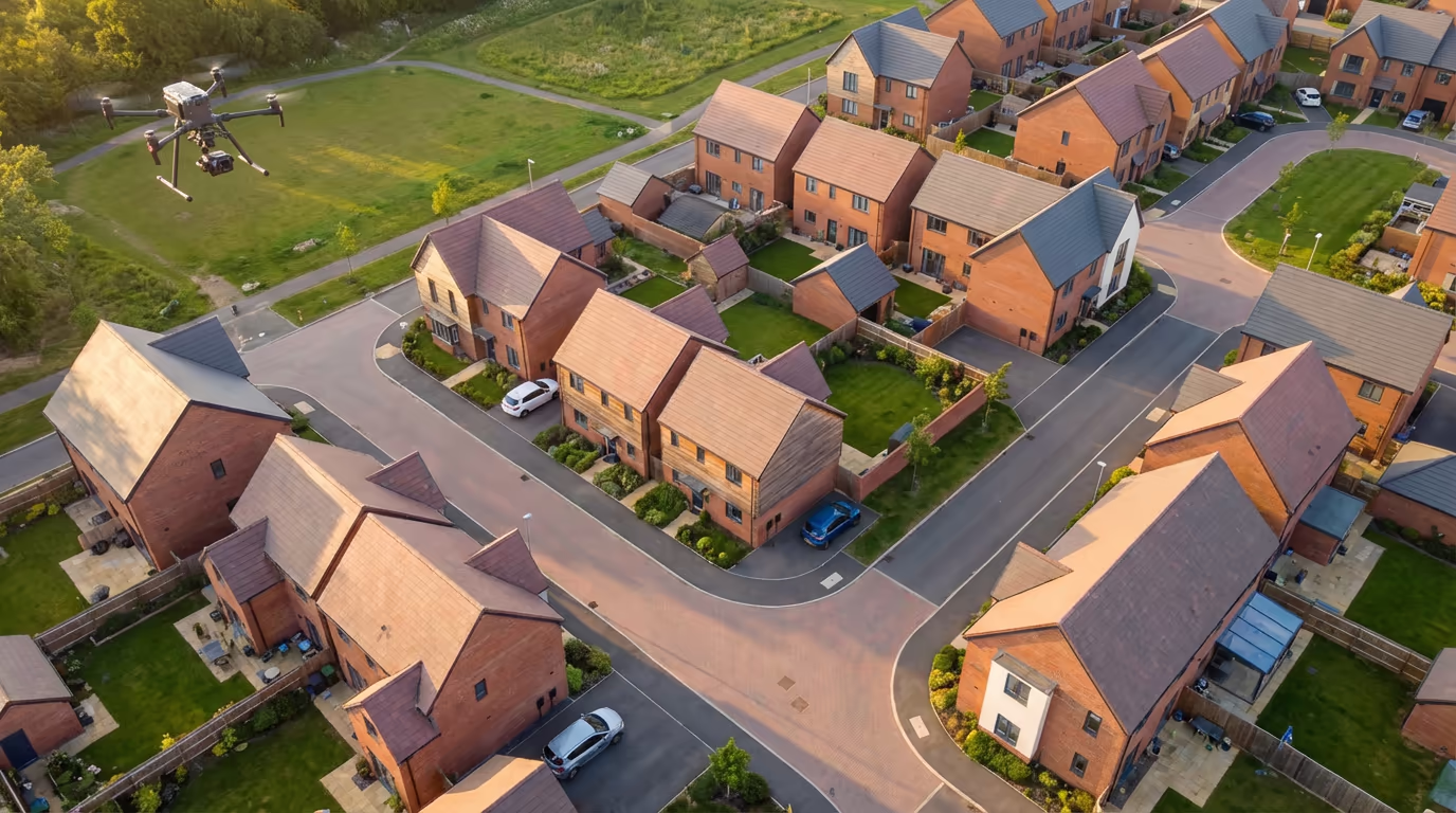
Drone As-Built Survey Service
Precision drone surveys documenting completed construction, verifying as-built conditions against design specifications.
Avg Response within 5 Mins • Or phone +44 1334 804554
Understanding Drone As-Built Surveys
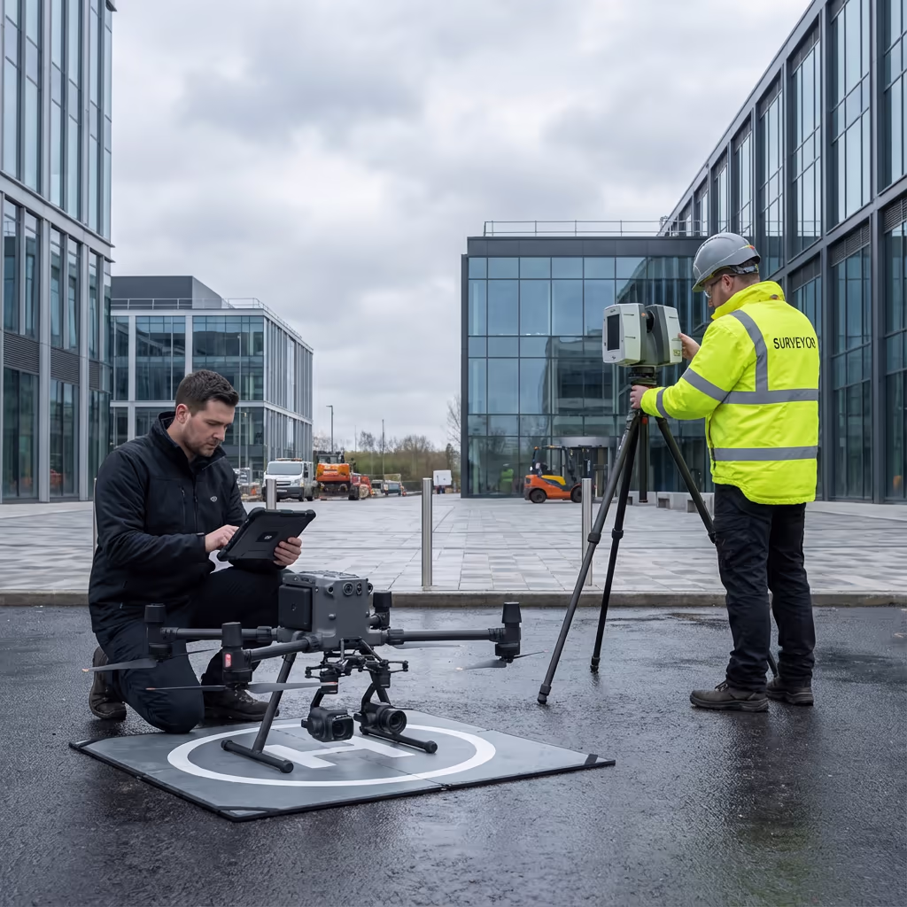
A UAV as-built survey captures the precise dimensions, positions, and conditions of completed construction works using drone photogrammetry and survey-grade GPS technology. It creates an accurate record of what was actually built, rather than what was planned, providing essential documentation for handover, compliance, and future reference.
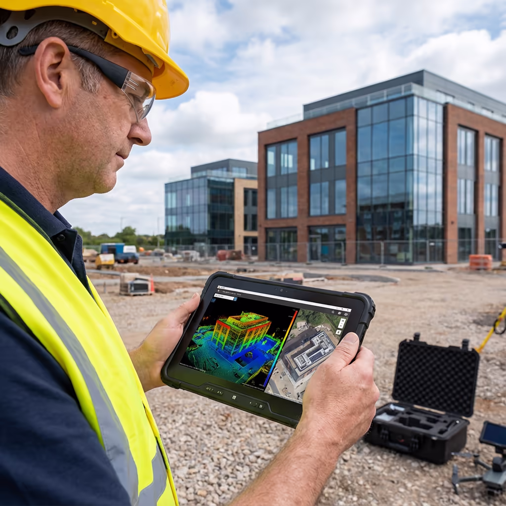
At Hire Drone Pilot, we deploy the latest drone technology to capture comprehensive as-built data quickly and accurately. Our surveys document everything from building positions and levels to infrastructure layouts and landscaping, delivering the precise measurements needed to verify construction against approved designs.

Peter Leslie
Owner & Drone Pilot
"Have questions? Ring me directly - I'm happy to discuss your project requirements."
Call NowPrecise As-Built Records,Delivered Rapidly
What You'll Receive
- Georeferenced orthomosaic
- As-built CAD drawings
- BIM comparison reports
- Survey-grade precision (±2-3cm)
Ready in 3-5 working days
Why Use HireDronePilot
- CAA authorised & fully insured
- Construction survey specialists
- Latest DJI & RTK technology
- UK-wide coverage
Relied upon by contractors, developers & local authorities throughout the UK.
Relied upon by leading organisations
Drone As-Built Survey Pricing Guide
Pricing depends on your project scope. Here is a guide to help you budget:
| Project Size | Guide Price |
|---|---|
| SmallSingle building | £500+ |
| MediumSmall development | £900+ |
| LargeMedium development | £1,500+ |
| Major DevelopmentLarge scheme | £2,500+ |
| Multi-PhasePhased projects | POA |
*Guide prices include standard deliverables. Final quote based on site complexity, access, and specific requirements.
What influences your quotation?
- Project size & complexity
- Required deliverables
- BIM comparison needs
- Turnaround time
Our drone approach typically saves 50-70% compared to conventional ground surveys while delivering faster turnaround. Contact us with your project details and we will provide a tailored quote within 24 hours.
Ready to receive a quote for your project?
Free, no-obligation quotes within 24 hours
Comparing Drone As-Built Survey and Conventional Methods
Conventional as-built surveys rely on ground-based total stations and manual measurements, requiring surveyors to physically access every point on site. This approach is time-consuming, labour-intensive, and often requires scaffolding or access equipment for elevated features.
UAV as-built surveys capture thousands of measurements in a single flight, creating comprehensive 3D models and orthomosaics that document the entire site from above. This drone perspective ensures nothing is missed, while RTK-enabled GPS delivers survey-grade precision without ground control points for most applications.
When to Select Each Approach
Opt for UAV As-Built
Speed & coverage
Opt for Conventional
Internal & detail work
Uncertain which approach suits your project?
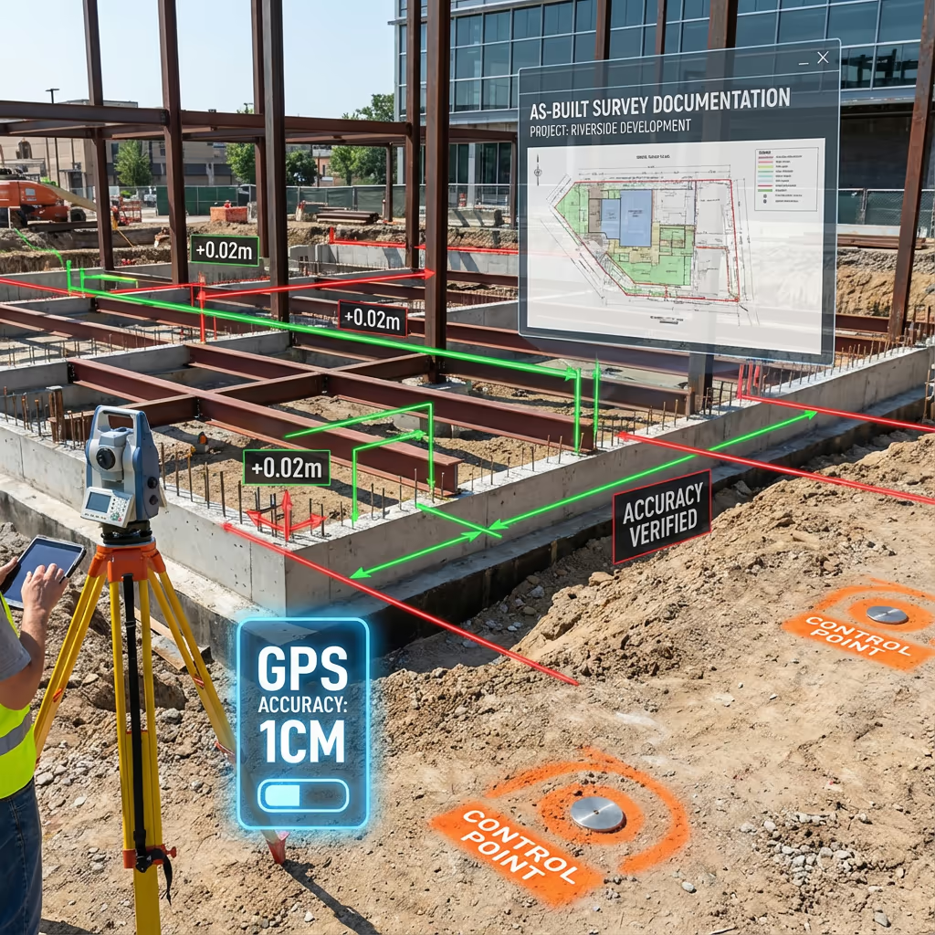
Precision Levels for Drone As-Built Surveys
Our UAV as-built surveys routinely achieve absolute precision of ±2-3cm horizontally and ±3-5cm vertically when using ground control points. For most construction verification purposes, this level of accuracy exceeds requirements and matches or beats conventional survey methods.
We use RTK-enabled drones with real-time GPS correction to ensure precise positioning throughout data capture. For projects requiring the highest precision, we establish ground control networks using survey-grade GNSS receivers. The result is reliable, repeatable data that stands up to scrutiny from clients, contractors, and planning authorities.

Applications of Drone As-Built Surveys
UAV as-built surveys serve critical functions across the construction lifecycle. Here are the key applications where our clients see the greatest value:
Project Handover
Comprehensive documentation of completed works for client acceptance, featuring accurate records of building positions, levels, and external features.
Planning Compliance
Evidence for planning condition discharge, demonstrating that construction matches approved drawings and specifications.
BIM Verification
Comparing completed construction against BIM models to identify deviations and update digital twins with as-built reality.
Dispute Resolution
Independent survey evidence for construction disputes, boundary disagreements, or defect claims requiring accurate measurements.
Asset Management
Creating accurate records for facilities management, maintenance planning, and future development considerations.
Infrastructure Recording
Documenting completed roads, drainage, utilities, and landscaping for adoption by local authorities or management companies.
Have a project that needs as-built documentation?

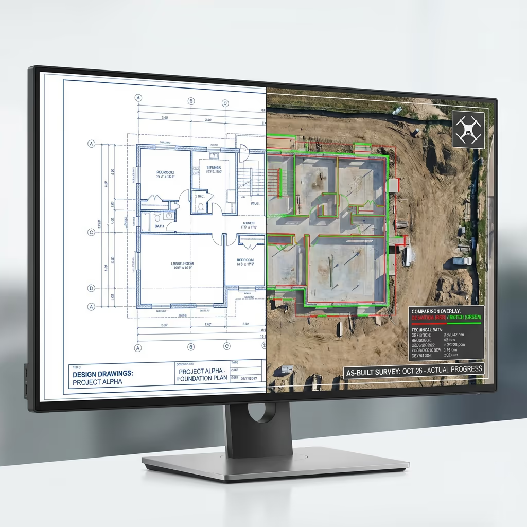
Can Drone As-Built Surveys Compare to BIM Models?
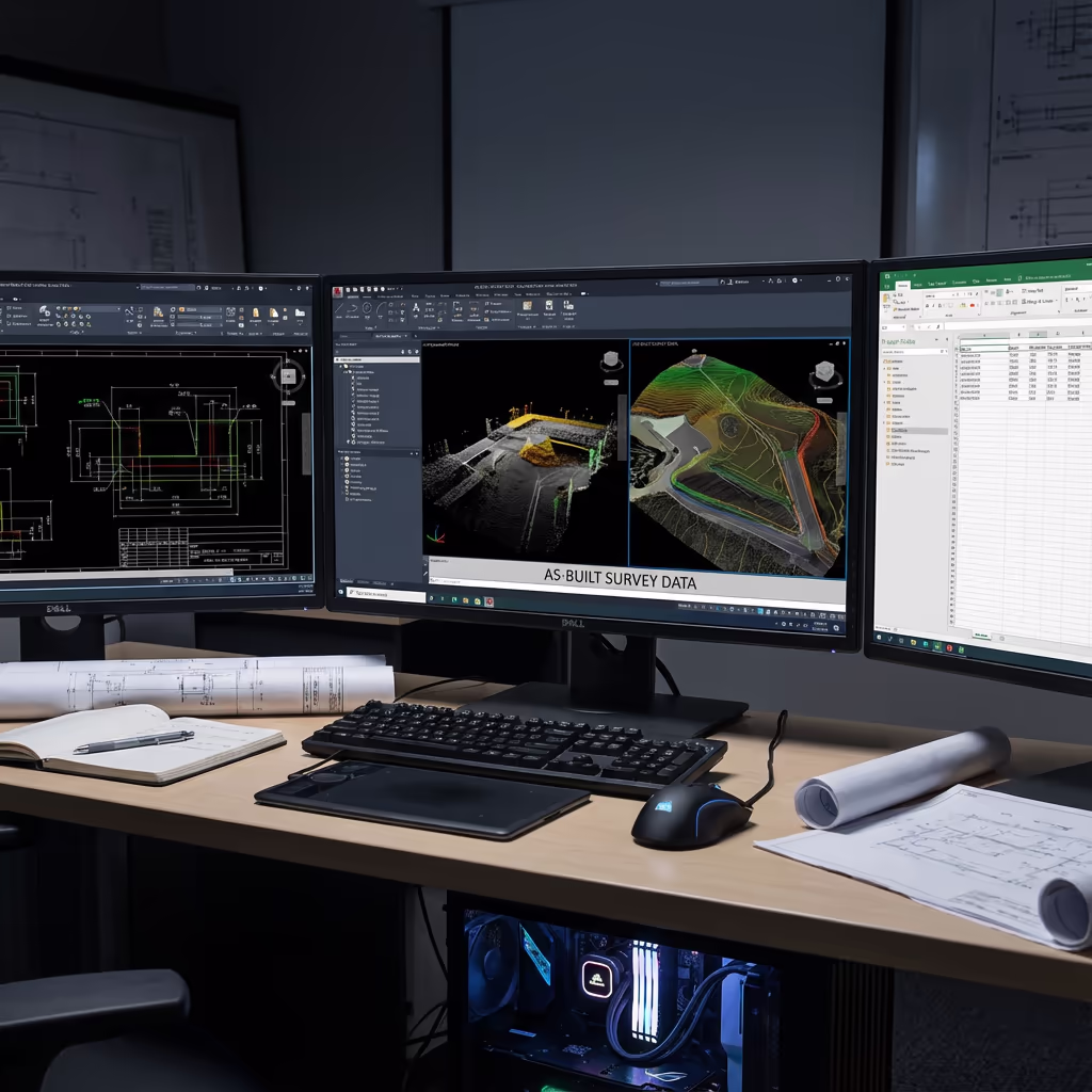
Absolutely—this is one of the most powerful applications of UAV as-built surveying. We create precise 3D point clouds and models from drone data that can be directly compared against your design BIM, identifying deviations between what was planned and what was built.
Our comparison reports highlight discrepancies using colour-coded deviation maps, making it immediately clear where construction differs from design intent. Whether you are verifying contractor performance, updating as-built models, or preparing for handover, this comparison capability provides objective evidence of construction precision.
BIM Comparison Deliverables
- Colour-coded deviation maps showing construction vs design
- Quantified deviation reports with measurements
- Updated as-built BIM models
- Clash detection between as-built and design elements
- Point cloud registration to design coordinates
Drone As-Built Survey Outputs
We tailor deliverables to your project requirements, but our standard as-built survey outputs include:
As-Built Orthomosaic
High-resolution georeferenced drone imagery showing the completed development in precise detail, suitable for measurements and annotations.
BIM Comparison Reports
Detailed deviation analysis comparing as-built data to design models, with colour-coded visualisations and measurement reports.
Deviation Reports
Quantified reports highlighting where construction differs from approved plans, with precise measurements of any discrepancies.
CAD Files (DWG/DXF)
Scaled CAD drawings in your preferred format, ready for integration with existing project documentation and design software.
3D Models
Photorealistic 3D models and point clouds for visualisation, measurement, and integration with BIM workflows.
Completion Records
Comprehensive documentation packages for project handover, planning discharge, and long-term asset records.
Need specific deliverables for your project?
Drone As-Built Survey Timeline
On-site data capture is remarkably efficient. A typical housing development can be surveyed in just 1-2 hours of flight time, plus setup and ground control establishment. Larger sites may require half a day to a full day depending on complexity.
Processing and delivery depends on project complexity and your required outputs. Standard deliverables are typically ready within 3-5 working days. For urgent handover deadlines, we offer expedited processing with 24-48 hour turnaround available at additional cost.
| Phase | Duration |
|---|---|
| Planning & Booking | 1-2 days |
| On-Site Data Capture | 2-4 hours |
| Processing | 1-2 days |
| BIM Comparison (if req) | 1-2 days |
| Deliverable Generation | 1 day |
| Total (Standard) | 3-5 working days |
Expedited Processing Available
Require faster delivery? 24-48 hour turnaround available for urgent projects.

Selecting a Drone As-Built Survey Provider
Not all UAV survey services are equal. When evaluating providers for as-built work, we recommend checking these key factors:
- CAA authorisation – Ensure they hold valid GVC or legacy PfCO permissions for commercial operations
- Construction experience – As-built surveys require understanding of construction workflows and client needs
- BIM capability – Can they compare to your design models and deliver deviation reports?
- Professional insurance – Public liability and professional indemnity cover appropriate to construction sites
- Relevant case studies – Request examples of similar construction projects they've documented
At Hire Drone Pilot, we satisfy every criterion. We are CAA authorised, fully insured, and have delivered as-built surveys for residential developments, commercial projects, and infrastructure schemes throughout the UK.
Ready to work with a reliable as-built survey provider?
Is Drone As-Built Survey More Affordable Than Conventional Methods?
In most scenarios, significantly more affordable. Conventional ground-based as-built surveys require surveyors to physically measure every element of completed construction, often needing scaffolding or access equipment for elevated features. This is time-consuming and labour-intensive.
Our UAV approach captures equivalent or better data in a fraction of the time. A development that might take a ground team several days can be surveyed in hours. The cost savings typically range from 50-70% compared to conventional methods, while delivering faster turnaround and comprehensive coverage. For large or complex sites, the economics become even more compelling.
Ready to Share Your As-Built Project?
Expert guidance • Tailored pricing • Avg Response within 5 Mins

Peter Leslie
Owner & Drone Pilot
With extensive experience in surveying and construction, Peter personally oversees every as-built project to ensure accuracy and professional delivery.
Quick Guide: UAV As-Built Surveys Explained
As-Built Deliverables
- As-built orthomosaic
- BIM comparison reports
- Deviation reports
- CAD files (DWG/DXF)
- 3D models & point clouds
- Completion records
Share Your Project
Receive expert guidance and tailored pricing.
Drone Pilot Reviews
Why Drone Pilots Rate HireDronePilot 5 Stars
Don't just take our word for it. Here's what drone pilots in our UK network say about getting work through the platform.
“I get relevant commercial briefs with clear scopes, so quoting is fast and accurate. It has helped me win consistent survey work without chasing low-quality leads.”
Adam Carter
Drone Pilot
“Since joining the platform, I have filled gaps in my schedule with quality roof and inspection jobs. The enquiry details are much better than generic lead forms.”
Sophie Bennett
Drone Pilot
“HireDronePilot makes it easier to focus on delivery. I can review project briefs quickly, submit competitive quotes, and pick up work in new regions.”
Daniel Khan
Drone Pilot