Surveying & Mapping
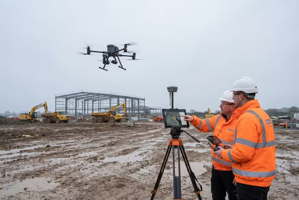
Drone Point Cloud Mapping
Generate high-density 3D point clouds from aerial photogrammetry and LiDAR sensors. Millions of precisely positioned data points delivering BIM-ready models, heritage records, and detailed terrain surfaces.
Avg Response within 5 Mins • Or call +44 1334 804554
What Is Drone Point Cloud Mapping?
A point cloud is a collection of millions of individual 3D data points, each with precise X, Y, and Z coordinates, that together form a detailed digital representation of a physical environment. Drone point cloud mapping uses UAVs equipped with cameras or LiDAR sensors to capture the data needed to generate these dense 3D datasets from above.
At Hire Drone Pilot, we produce point clouds through two primary methods: photogrammetry (using overlapping aerial photographs processed through specialised software) and LiDAR (using laser scanning to directly measure distances). The resulting point clouds can contain hundreds of millions of points, providing an extraordinarily detailed 3D record of buildings, terrain, vegetation, and infrastructure.
Peter Leslie
Owner & Drone Pilot
"Have questions? Ring me directly - I'm happy to discuss your project requirements."
Call NowMillions of Data Points,One Precise 3D Model
What You'll Receive
- Dense classified point clouds
- Textured 3D mesh models
- BIM-ready deliverables
- Cross-sections & elevation data
Delivered in 5-10 working days
Why Use HireDronePilot
- CAA certified & fully insured
- Photogrammetry & LiDAR capability
- In-house point cloud processing
- Nationwide UK coverage
Trusted by architects, BIM managers, heritage professionals & engineers across the UK.
Trusted by leading organisations
How Much Does Point Cloud Mapping Cost?
Point cloud mapping pricing depends on the site area, required density, capture method, and deliverable formats. Here is a guide to assist with budgeting:
| Project Scope | Guide Price |
|---|---|
| Small SiteSingle building or plot | £500+ |
| Medium Site1-5 hectares | £900+ |
| Large/Complex Site5+ hectares or complex geometry | £1,500+ |
| Heritage BuildingDetailed recording | POA |
| LiDAR Upgrade | +50% |
*Guide prices include standard deliverables. Final quotation depends on project complexity, required density, and output formats.
Factors Influencing Your Quote
- Site area & geometric complexity
- Photogrammetry vs LiDAR method
- Required point density
- Output format & BIM requirements
Compared to terrestrial laser scanning which requires multiple station setups and extensive site access, drone point cloud mapping typically saves 30-50% on costs while capturing data from angles that ground-based scanners cannot reach. Send us your project details and we will provide a tailored quotation within 24 hours.
Ready to receive a quote for point cloud mapping?
Free, no-obligation quotes within 24 hours
Photogrammetry vs LiDAR Point Clouds
Photogrammetry generates point clouds by analysing overlapping photographs from multiple angles, producing coloured (RGB) point clouds ideal for open terrain and buildings. LiDAR fires laser pulses to calculate distances directly, producing extremely dense point clouds at hundreds of thousands of points per second. Crucially, LiDAR can penetrate vegetation canopy, making it essential for mapping ground surfaces beneath tree cover—something photogrammetry cannot achieve.
Which Method Suits Your Project?
Photogrammetry
RGB colour, lower cost
LiDAR
Higher density, vegetation penetration
Not sure which method suits your project?
What Point Density Can Drone Point Cloud Mapping Achieve?
Photogrammetric point clouds from our drone surveys typically achieve densities of 100-500 points per square metre, depending on flight altitude and camera resolution. LiDAR point clouds achieve even higher densities, typically 100-1,000+ points per square metre with multiple returns per pulse. This multi-return capability is what enables ground surface extraction beneath vegetation. Positional accuracy of 1-3cm is routinely achieved with RTK GPS corrections and ground control points, ensuring the point cloud aligns precisely with real-world coordinates.
Where Is Point Cloud Mapping Used?
Point cloud data serves a wide range of industries where precise 3D spatial information is essential. Here are the primary applications where our clients derive the greatest value:
BIM & Construction
As-built point clouds imported into Revit, ArchiCAD, or other BIM platforms for clash detection, progress tracking, and digital twin creation.
Heritage Recording
Detailed 3D records of listed buildings, monuments, and archaeological sites for conservation, restoration planning, and Historic England submissions.
Terrain & Landscape
Ground surface extraction beneath vegetation for forestry management, flood modelling, and landscape architecture design work.
Infrastructure Assessment
Detailed 3D records of bridges, pylons, pipelines, and utilities for condition assessment, design verification, and asset management.
Volumetric Analysis
Precise stockpile measurements, cut-and-fill calculations, and earthworks quantification from dense point cloud surfaces.
Deformation Monitoring
Repeat surveys comparing point clouds over time to detect structural movement, subsidence, or terrain changes with millimetre precision.
Need point cloud data for your project?
What Deliverables Do You Receive From Point Cloud Mapping?
We tailor outputs to your workflow requirements, but our standard point cloud mapping packages include:
Classified Point Cloud
Dense point cloud with automatic classification (ground, vegetation, buildings, noise) in LAS/LAZ format for use in any compatible software.
Textured 3D Mesh Model
Photorealistic 3D model generated from the point cloud, suitable for visualisation, stakeholder presentations, and virtual walkthroughs.
Digital Surface & Terrain Models
DSM and DTM rasters derived from the point cloud for contour generation, cross-sections, and integration with GIS platforms.
BIM-Ready Exports
Point clouds exported in E57 or RCP format for direct import into Revit, Navisworks, or other BIM authoring software.
Need specific output formats?
How Long Does Point Cloud Processing Take?
On-site data capture is rapid—a typical building or small site can be flown in 30-60 minutes. Medium sites of several hectares require 2-4 hours including ground control establishment. The processing phase takes considerably longer due to the computational intensity of generating dense point clouds.
Photogrammetric point cloud generation involves aligning hundreds or thousands of images, computing depth maps, and building the dense cloud. This typically takes 3-5 days for standard projects. LiDAR datasets require less processing time but still need classification, filtering, and quality checks. Complex projects requiring BIM integration may take 7-10 working days.
| Phase | Duration |
|---|---|
| Planning & Preparation | 1-3 days |
| On-Site Data Capture | 30 mins - 4 hrs |
| Point Cloud Generation | 2-5 days |
| Deliverable Production | 1-3 days |
| Total (Standard) | 5-10 working days |
How to Choose a Point Cloud Mapping Provider
Point cloud mapping demands specialist skills in both data capture and processing. When evaluating providers, we recommend checking these essential criteria:
- CAA certification – Valid GVC permissions for commercial drone operations
- Processing expertise – In-house photogrammetry and point cloud processing capability, not outsourced
- Software proficiency – Experience with industry-standard tools such as Pix4D, Agisoft, CloudCompare, and RealityCapture
- BIM knowledge – Understanding of BIM workflows and formats if integration is required
- Quality assurance – Documented QA processes including accuracy verification against control points
Ready to work with a specialist point cloud provider?
Integrating Point Clouds with BIM
One of the most valuable applications of drone point cloud data is integration with BIM platforms. Importing a georeferenced point cloud into Revit, ArchiCAD, or Navisworks provides architects and engineers with an accurate 3D reference of existing conditions. We deliver in E57 and RCP formats optimised for BIM software. For as-built verification, overlaying the point cloud against design models reveals discrepancies immediately, enabling rapid identification of construction errors before they become costly to rectify.
Terrestrial Laser Scanning
- Scanner hire & crew (2-3 days)£2,000-£5,000
- Registration & processing£500-£1,500
- Limited aerial coverageAdditional cost
- Typical Total£2,500-£6,500
Drone Point Cloud Mapping
- Full drone survey & processing£500-£1,500
- Aerial coverage includedIncluded
- BIM export (E57/RCP)Included
- Typical Total£500-£1,500
Ready for 3D Point Cloud Data?
Expert guidance • Tailored pricing • Avg Response within 5 Mins

Peter Leslie
Owner & Drone Pilot
With deep expertise in photogrammetry and 3D data processing, Peter personally manages every point cloud project to ensure the data meets your accuracy and format requirements.
Quick Guide: Point Cloud Mapping
Project Deliverables
- Classified point clouds (LAS/LAZ)
- Textured 3D mesh models
- Digital surface & terrain models
- BIM-ready exports (E57/RCP)
- Cross-sections & profiles
- Professional survey reports
Discuss Your Project
Get expert guidance and tailored pricing.
Drone Pilot Reviews
Why Drone Pilots Rate HireDronePilot 5 Stars
Don't just take our word for it. Here's what drone pilots in our UK network say about getting work through the platform.
“I get relevant commercial briefs with clear scopes, so quoting is fast and accurate. It has helped me win consistent survey work without chasing low-quality leads.”
Adam Carter
Drone Pilot
“Since joining the platform, I have filled gaps in my schedule with quality roof and inspection jobs. The enquiry details are much better than generic lead forms.”
Sophie Bennett
Drone Pilot
“HireDronePilot makes it easier to focus on delivery. I can review project briefs quickly, submit competitive quotes, and pick up work in new regions.”
Daniel Khan
Drone Pilot
Related Services
Drone Surveys
Comprehensive aerial surveys delivering topographic data, orthomosaics, and terrain models.
LiDAR Mapping
Laser scanning from drone platforms for vegetation penetration and ultra-dense 3D data.
Construction Monitoring
Regular progress surveys with point cloud comparison against BIM design models.