Surveying & Mapping
Drone Elevation Survey Service
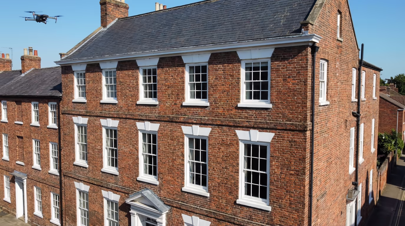
Capture detailed building facades and elevations with precision drone technology. Orthorectified imagery and precise measurements without scaffolding or access equipment.
Avg Response within 5 Mins • Or phone +44 1334 804554
Understanding Drone Elevation Surveys
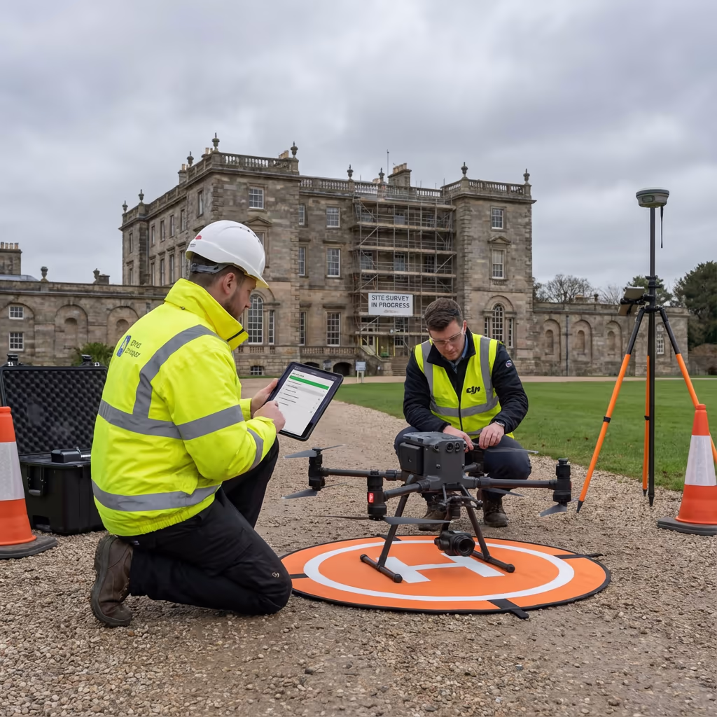
A UAV elevation survey captures detailed imagery of building facades and vertical surfaces using our expert drone systems. Unlike ground-based photography, our drones fly at precise distances parallel to each face of a building, capturing high-resolution images that we process into orthorectified elevation drawings.
At Hire Drone Pilot, we use advanced photogrammetry techniques to transform these images into scale-accurate facade records. The resulting elevation drawings show true dimensions—you can measure directly from them with millimetre precision. This makes UAV elevation surveys invaluable for architects, heritage specialists, and anyone needing detailed building records without expensive scaffolding.

Peter Leslie
Owner & Drone Pilot
"Have questions? Ring me directly - I'm happy to discuss your project requirements."
Call NowSurvey-Grade Elevation Data,No Scaffolding Required
What You'll Receive
- Orthorectified facade images
- Scaled elevation drawings
- 3D facade models
- CAD-ready files (DXF/DWG)
Ready in 3-5 working days
Why Use HireDronePilot
- CAA authorised & fully insured
- Specialist facade processing
- Latest DJI technology
- UK-wide coverage
Relied upon by architects, heritage consultants & property professionals throughout the UK.
Relied upon by leading organisations
Drone Elevation Survey Pricing Guide
Pricing depends on building size and complexity. Here is a guide to help you budget:
| Project Type | Guide Price |
|---|---|
| Single Facade1 elevation | £350+ |
| Small Building2-4 facades | £500+ |
| Medium BuildingMulti-storey | £800+ |
| Large/ComplexHeritage/complex form | £1,200+ |
| Multi-BuildingEstate/campus | POA |
*Guide prices include standard deliverables. Final quote based on building height, access, and specific requirements.
What influences your quotation?
- Building height & complexity
- Number of facades
- Access restrictions
- Required deliverables
Our drone approach typically saves 60-80% compared to conventional scaffolding surveys. Contact us with your project details and we will provide a tailored quote within 24 hours.
Ready to receive a quote for your project?
Free, no-obligation quotes within 24 hours
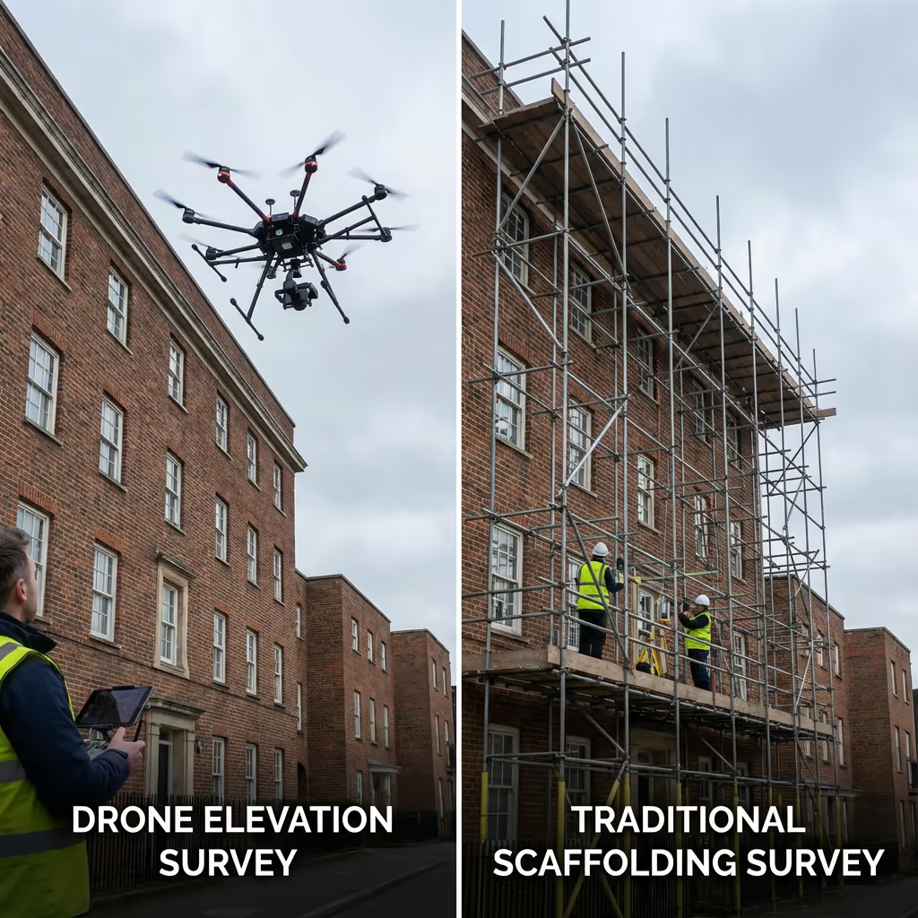
Comparing Drone Elevation Survey and Conventional Methods
Conventional building elevation surveys typically require scaffolding, cherry pickers, or rope access to capture facade imagery at height. This means significant setup costs, site disruption, and health and safety considerations. A single facade on a three-storey building might need £2,000+ of scaffolding hire before any survey work begins.
UAV elevation surveys eliminate these access costs entirely. Our drones capture imagery from any height and angle without touching the building, working around obstacles and reaching areas that would be impractical or hazardous for conventional methods. We complete most elevation surveys in a single day with minimal site disruption.
When to Select Each Method
UAV Elevation Survey
Rapid & cost-effective
Conventional Methods
Scaffolding/access required
Uncertain which method suits your project?
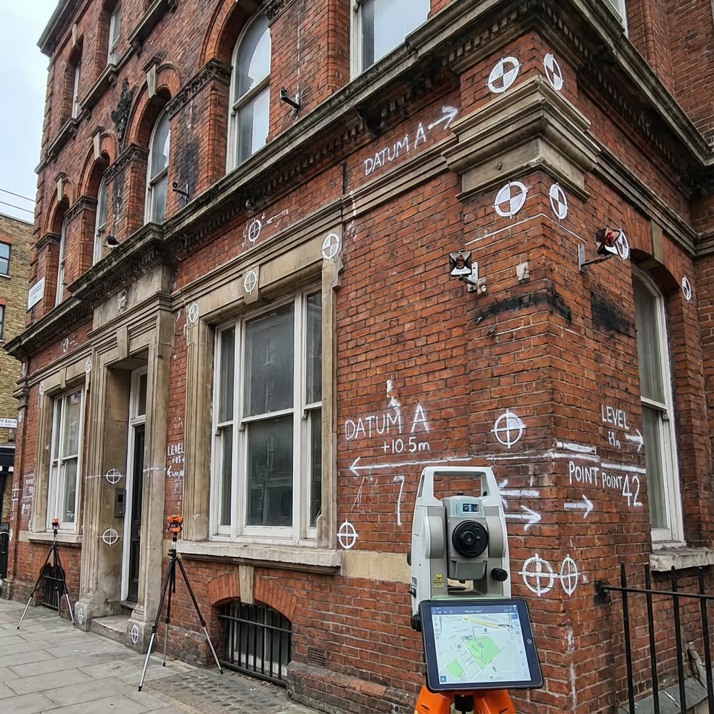
Precision Levels for Drone Elevation Surveys
Our UAV elevation surveys routinely achieve precision of ±5-10mm across the facade surface when using ground control points. This level of precision exceeds the requirements for most architectural, heritage, and planning applications.
We achieve this through careful flight planning at optimal distances from the building, high-overlap image capture, and rigorous photogrammetric processing. For projects requiring the highest precision, we establish survey control networks and validate measurements against known references. The resulting orthorectified images are true-to-scale—you can measure window dimensions, crack widths, or architectural details directly from the deliverables.
Drone Elevation Survey Applications
UAV elevation surveys serve a wide range of industries and purposes. Here are the key applications where our clients see the greatest value:
Heritage & Conservation
Recording listed buildings, condition surveys for conservation plans, and detailed facade documentation for heritage applications.
Architecture & Design
As-built facade records for refurbishment projects, extension designs, and building information modelling (BIM) input.
Property & Asset Management
Building condition assessments, facade inspection records, and portfolio documentation for estates and facilities teams.
Planning & Development
Accurate elevation drawings for planning applications, impact assessments, and development proposals.
Insurance & Claims
Pre and post-loss documentation, defect surveys, and detailed records for dispute resolution and claims support.
Facade Maintenance
Identifying repair requirements, scheduling maintenance works, and tracking building condition over time.
Have a building that needs elevation survey?
Can Drone Elevation Surveys Capture All Building Faces?
In most cases, yes. Our drones can capture facades that face any direction, including north-facing elevations that rarely receive direct sunlight. We plan flights to optimise lighting conditions across all faces, often capturing different elevations at different times of day for consistent image quality.
However, some situations present challenges. Buildings very close to boundaries may have restricted airspace for drone operations. Internal courtyards or light wells with limited overhead clearance can be difficult to access. In these cases, we assess each facade individually and advise on the best approach—sometimes combining drone capture with ground-based photography for complete coverage. We will always be upfront about any limitations during the quotation process.
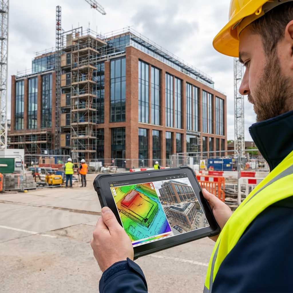
Drone Elevation Survey Outputs
We tailor deliverables to your project requirements, but our standard UAV elevation survey outputs include:
Orthorectified Facade Images
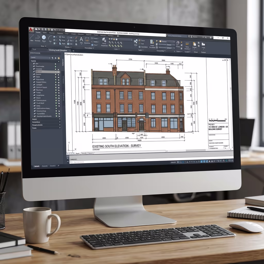
True-to-scale photographic images of each facade, corrected for perspective distortion. Measure directly from the image in any software.
Elevation Drawings
Professional architectural elevation drawings with key dimensions annotated. Supplied as PDF and CAD formats.
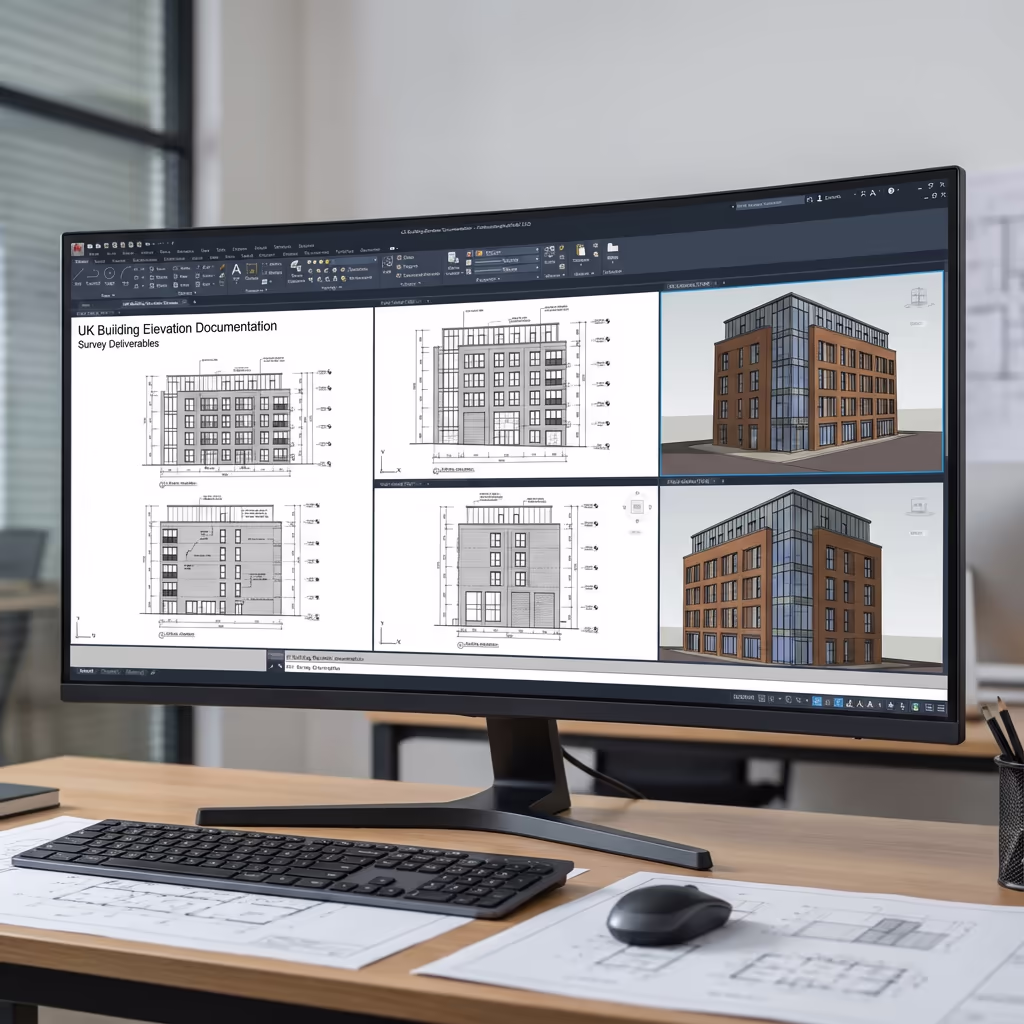
3D Facade Models
Textured 3D mesh models of building facades for visualisation, BIM integration, and detailed analysis.
CAD Files (DXF/DWG)
Ready-to-use vector files compatible with AutoCAD, Revit, and other design software. Scale-accurate and georeferenced.
Measurement Data
Comprehensive measurement reports including overall dimensions, window schedules, and feature locations as required.
Need specific deliverables for your project?
Drone Elevation Survey Timeline
On-site data capture is typically completed in a single visit. A small building with four facades takes 1-2 hours of flight time. Larger or more complex buildings may require half a day. We work efficiently to minimise disruption to building occupants and neighbours.
Processing and delivery depends on project complexity. Standard deliverables for a typical building are ready within 3-5 working days. Complex heritage projects with detailed annotation requirements may take 5-7 days. For urgent projects, we offer expedited processing—ask about rapid-track options when you get in touch.
| Phase | Duration |
|---|---|
| Planning & Permissions | 1-2 days |
| On-Site Data Capture | 2-4 hours |
| Image Processing | 1-2 days |
| Deliverable Production | 1-2 days |
| Total (Standard) | 3-5 working days |
Expedited Processing Available
Require faster delivery? 24-48 hour turnaround available for urgent projects.

Selecting a Drone Elevation Survey Provider
Not all drone survey providers have the expertise for elevation work. When evaluating providers, we recommend checking these key factors:
- CAA authorisation – Ensure they hold valid GVC or legacy PfCO permissions for commercial operations
- Professional insurance – Public liability and professional indemnity cover appropriate to building survey work
- Facade survey experience – Elevation surveys require specialist knowledge in vertical photogrammetry
- CAD capability – Ask about their processing workflow and deliverable formats
- Relevant case studies – Request examples of similar building surveys they've completed
At Hire Drone Pilot, we satisfy every criterion. We are CAA authorised, fully insured, and have delivered elevation surveys for heritage buildings, commercial properties, and residential developments throughout the UK.
Ready to work with a reliable elevation survey provider?
Is Drone Elevation Survey More Affordable Than Conventional Methods?
In almost every case, significantly more affordable. Conventional elevation surveys require physical access to the building face—typically via scaffolding, cherry picker, or rope access. For a three-storey building, scaffolding alone can cost £2,000-5,000 before any survey work begins. Add the surveyor's time, traffic management, and building occupation disruption, and costs escalate rapidly.
Our UAV elevation surveys eliminate these access costs entirely. We capture the same quality imagery—often better—without touching the building. The total cost typically represents a 60-80% saving compared to conventional scaffolding-based surveys, while delivering faster turnaround and causing minimal site disruption. For multi-storey or difficult-access buildings, the savings are even more significant.
Ready to Discuss Your Elevation Survey Project?
Expert advice • Tailored pricing • Avg Response within 5 Mins

Peter Leslie
Owner & Drone Pilot
With extensive experience in surveying and UAV operations, Peter personally oversees every elevation survey to ensure accurate, professional deliverables.
Quick Guide: UAV Elevation Surveys Explained
Elevation Survey Deliverables
- Orthorectified facade images
- Elevation drawings (PDF/CAD)
- 3D facade models
- CAD files (DXF/DWG)
- Measurement data
- High-res source imagery
Share Your Project
Receive expert advice and tailored pricing.
Drone Pilot Reviews
Why Drone Pilots Rate HireDronePilot 5 Stars
Don't just take our word for it. Here's what drone pilots in our UK network say about getting work through the platform.
“I get relevant commercial briefs with clear scopes, so quoting is fast and accurate. It has helped me win consistent survey work without chasing low-quality leads.”
Adam Carter
Drone Pilot
“Since joining the platform, I have filled gaps in my schedule with quality roof and inspection jobs. The enquiry details are much better than generic lead forms.”
Sophie Bennett
Drone Pilot
“HireDronePilot makes it easier to focus on delivery. I can review project briefs quickly, submit competitive quotes, and pick up work in new regions.”
Daniel Khan
Drone Pilot