Airport Drone Detection: What UK Airports Actually See
Peter Leslie
16 Apr 2026
Key Takeaways
- Most UK airports and airfields sit inside a Flight Restriction Zone — a 5 km circle with 1 km extensions at each runway end — and flying inside it without permission is a criminal offence
- Airports combine radio-frequency scanners, acoustic sensors, optical and thermal cameras and dedicated drone radar, because conventional airport radar was never built to see small plastic drones
- Since 1 January 2026, UK1, UK2, UK3, UK5 and UK6 class drones must broadcast Remote ID, which pushes your Operator ID, the drone serial number, the drone position and your own ground position out to anyone listening
- Endangering the safety of an aircraft carries up to five years in prison under the Air Navigation Order 2016, and a Flight Restriction Zone infringement is itself a mandatory-report occurrence to the CAA
- The legal route into a Flight Restriction Zone is the airport’s air traffic control — you request permission directly, every time, without exception
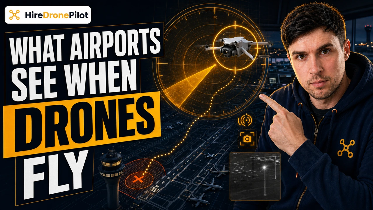
Airports do not guess that a drone is in their airspace. They see it on radio frequency, they hear it on acoustic arrays, they look at it through long-lens cameras, and since January 2026 the drone itself has been broadcasting its Operator ID, its serial number and the ground position of whoever is holding the controller. If you are flying near a UK airport without permission, the question is not whether you will be spotted. It is how many of those channels report you at the same time.
This is the reality of airport drone detection in 2026, the legal framework wrapped around it, and why a recreational flight close to a runway is one of the fastest ways a drone pilots case lands on a desk at the UK Civil Aviation Authority.
Most UK airports sit inside a 5 km Flight Restriction Zone with 1 km runway extensions, and that zone is a legal fence, not a suggestion
The Drone and Model Aircraft Code is blunt on this point. Most airports, airfields and spaceports sit inside a Flight Restriction Zone — an FRZ. The typical shape is a five-kilometre circle around the site, with one-kilometre rectangular extensions running off each runway end. Spaceports use a straight five-kilometre circle. Some smaller airfields do not hold an FRZ at all, but the Code still prohibits you from flying near them in a way that could pose a danger to any aircraft.
The wording in Rule 7 of the Code is worth reading at the pace it deserves. If you endanger the safety of an aircraft, you could go to prison for five years. That sentence is the cornerstone around which every other airport-detection rule is built.
In practice this means two things. The boundary of an FRZ is the legal boundary of airport airspace for you as a drone operator, and it is pinned down to the metre on the NATS airspace map. You do not use your drone app alone to check — built-in drone software is not always up to date, and many short-notice restrictions never appear inside the manufacturer’s map. You cross-check against an independent source every single time, and where the FRZ bites, the only legal way in is the airport’s own air traffic control granting you permission.
Airport drone detection runs on multiple sensors at once, because no single one is enough
Traditional primary surveillance radar at an airport was designed to track manned aircraft — large, metallic, and built to return a strong radar signal. A small plastic drone does not. That is why modern UK airports do not lean on their existing radar alone to manage drone activity, and instead deploy purpose-built counter-drone systems in layers.
The four channels that do the heavy lifting are radio-frequency scanners, acoustic sensors, electro-optical and infrared cameras, and dedicated drone radar. Each one has a strength and a weakness, and airports overlap them so a failure in any single channel does not produce a blind spot.
What each sensor contributes
| Sensor | How it works | Where it struggles |
|---|---|---|
| RF scanner | Detects the command-and-control link between drone and controller, and can classify the make and model. | Confused by other radio traffic; needs a current signal library to classify. |
| Acoustic array | Listens for propeller signatures to classify the drone type at close range. | Short range; very weak in the noisy environment around a runway. |
| Electro-optical / thermal camera | High-zoom daylight and infrared cameras with AI pattern recognition for visual confirmation. | Weather and light dependent; false positives from birds. |
| Drone radar | Purpose-built radar tuned for small, low, slow targets. | Expensive; still weaker against sub-250 g drones than against larger drones. |
When all four layers are running, the airport is not watching a single screen waiting for a blip. It is correlating RF fingerprints against radar tracks against camera feeds, and a consumer drone inside the FRZ will trip most of them inside seconds.
Since January 2026, Remote ID has turned your drone into its own witness
The biggest shift in airport detection is not a new radar. It is legal. From 1 January 2026, UK1, UK2, UK3, UK5 and UK6 class drones must have Remote ID activated whenever they fly. From 1 January 2028, Remote ID becomes mandatory for almost every drone and model operation in the country, including UK0 drones over 100 g that carry a camera, legacy drones and privately built drones. The transitional concessions that existed before 2026 have now closed.
What Remote ID actually broadcasts during the flight is a short list, but it is exactly the list an airport wants. Your Operator ID. The drone’s unique serial number. The drone’s live geographical position and its height above surface or take-off point. The route it is flying. The geographical position of the Remote Pilot — which is to say, you, on the ground, with the controller in your hands. Plus an emergency-status flag, for example low battery.
Before Remote ID, pinning the drone operator to a location meant triangulating the control signal, which takes time. After Remote ID, the drone itself publishes your ground position every few seconds. From the airport’s side, the workflow of how you identify a drone operator has collapsed from a chase into a broadcast feed.
The broadcast itself does not contain your name. It contains your Operator ID and your position. Only the CAA and authorised organisations can resolve that ID back to a person — but the police are one of those authorised organisations, and an FRZ infringement is exactly the trigger that unlocks the lookup.
A confirmed drone near a runway triggers a rehearsed response, not a phone call
UK airports run major-incident playbooks for unauthorised drone activity, and the response is coordinated rather than improvised. Air traffic control is alerted the moment detection is confirmed and may pause departures, reroute arrivals, or close runways while the situation is assessed. Airport security coordinates with local police, and the police powers that apply to drone operators include stop, search, and seizure of the drone and its controller.
On the reporting side, a Flight Restriction Zone infringement is itself a mandatory-report occurrence under the CAA’s UAS occurrence framework — the event is logged whether or not the flight ended in a collision. That paper trail is what keeps these cases alive for prosecution long after the drone has landed.
If you see suspicious activity at an airport, the reporting channel is explicit. Call local police on 101, or airport security if you are already on site. Do not try to intervene — the airport has the equipment, the legal authority and the training, and you almost certainly do not.
The legal backbone is the Air Navigation Order 2016, and the penalty ceiling is five years in prison
All of this sits on top of the Air Navigation Order 2016, which works in parallel with the UK Regulations (EU) 2019/945 and 2019/947. Endangering the safety of an aircraft carries up to five years’ imprisonment. Flying inside a Flight Restriction Zone without permission is a criminal offence in its own right. Flying without the correct registration, without an activated Remote ID where it is required, or outside the rules of the Open Category stacks further offences on top.
The commercial consequences bite just as hard. Flying outside the rules invalidates your third-party drone insurance, which converts any accident from an insurance claim into direct personal liability. If the flight disrupts operations, airport carriers will look to recover the costs of delayed departures, reroutes and ground handling — which scale into millions of pounds inside a few hours.
This is also why Beyond Visual Line of Sight flight near an airport is not available to the Open Category at all. Any operation that needs altitude, distance or proximity near an aerodrome routes through the Specific Category, an Operational Authorisation, and a direct conversation with the airport — not a workaround.
The legitimate route into an FRZ is permission from the airport’s air traffic control, every time
Drone work near airports is not forbidden — surveyors, film crews and infrastructure inspectors operate inside FRZs routinely. What is forbidden is doing it without permission. The correct process is to identify the airport that controls the zone, contact the air traffic control unit directly, and agree the time, altitude ceiling, distance, and radio or phone contact for the flight. Some airports publish an online request form; others expect a phone call with your operator details to hand.
You hold a briefed slot, not an open window. If the airport changes its operations, the slot changes too, and you land. That discipline is the difference between a paying job and a five-year sentence, and it is not negotiable.
So the short answer to can airports see my drone is yes, and more comprehensively now than at any point in the past decade. Radar, radio frequency, acoustic signature, optical and thermal cameras, and the drone’s own Remote ID broadcast all point at the same airspace — and at the person holding the controller on the ground.
If the job needs altitude or proximity near a runway, the only correct move is to go through air traffic control. For the wider picture on which rules sit on top of this, our UK drone laws explainer is the place to go next.
Got a specific scenario you want covered — a job inside an FRZ, a Remote ID question, an airport that is not responding to a request? Drop a note to peter@hiredronepilot.uk and I will come back to you directly. If you prefer the video version of this explainer, the comments are open on YouTube.
References
Primary source material for this article is the UK Civil Aviation Authority. External links open in a new tab.
- UK CAA — The Drone and Model Aircraft Code (CAP2320) · Rule 7 Flight Restriction Zones, 5 km + 1 km runway extensions, five-year prison penalty for endangering an aircraft
- UK CAA — Remote ID (RID) · January 2026 activation dates, broadcast data list, Operator ID and private key handling
- UK CAA — Airspace (aerodromes and restrictions) · airspace restrictions, aerodrome buffers, NOTAM process, geo-awareness
- UK CAA — UAS Occurrence Reporting · FRZ infringements as mandatory-report occurrences
- UK CAA — Privacy and illegal use of drones · flying close to airports without authorisation is illegal; reporting channels
- UK CAA — UK Regulatory Framework for Drones · Air Navigation Order 2016 and the UAS Regulations (EU) 2019/945 and 2019/947

Peter Leslie
Founder & GVC Drone Pilot
Peter is the founder of HireDronePilot. With thousands of logged commercial flight hours, he writes about drone technology, commercial surveying tactics, and UK aviation compliance.
Connect on LinkedIn