Specialist Services
Drone Bathymetric Survey
Map underwater terrain, measure water body depths, and generate detailed bed profiles using drone-deployed sonar technology. Rivers, lakes, reservoirs, and coastal environments surveyed safely from above.
Avg Response within 5 Mins • Or call +44 1334 804554
What Is a Drone Bathymetric Survey?
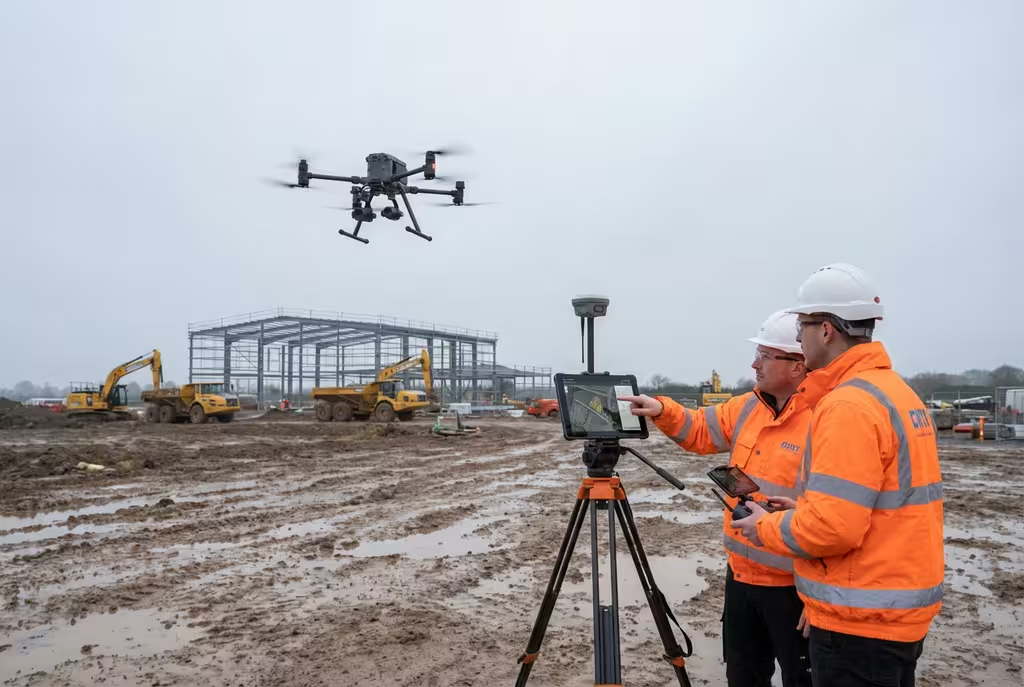
A drone bathymetric survey uses unmanned aerial vehicles equipped with echo sounder payloads or integrated sonar sensors to measure the depth and map the underwater topography of rivers, lakes, reservoirs, ponds, and coastal areas. The drone flies precise transects over the water surface while the tethered or mounted sonar device records depth readings at high frequency.
At Hire Drone Pilot, we combine this underwater depth data with aerial photogrammetry of the surrounding terrain to produce seamless topo-bathymetric models. This gives you a complete picture of the entire site—above and below the waterline—in a single survey operation. The result is georeferenced depth charts, bed profiles, and volumetric data that would traditionally require boat-based survey teams.
Peter Leslie
Owner & Drone Pilot
"Have questions? Ring me directly - I'm happy to discuss your project requirements."
Call NowMap Above & Below,In a Single Survey
What You'll Receive
- Detailed depth charts & bed profiles
- Volumetric capacity calculations
- Topo-bathymetric merged models
- Cross-section & longitudinal profiles
Delivered in 5-10 working days
Why Use HireDronePilot
- CAA certified & fully insured
- No boat or vessel required
- Minimal environmental disturbance
- Combined aerial & underwater data
Trusted by water companies, environmental consultancies & civil engineers across the UK.
Trusted by leading organisations
How Much Does a Drone Bathymetric Survey Cost?
Bathymetric survey pricing depends on the water body size, depth, accessibility, and the deliverables required. Here is a guide to assist with budgeting:
| Survey Scope | Guide Price |
|---|---|
| Small Water BodyPond, small lake | £800+ |
| River SectionUp to 1km stretch | £1,200+ |
| Large Reservoir/Lake1+ hectare water area | £2,000+ |
| Coastal/EstuarineComplex environments | POA |
| Topo-Bathy Combined | +30% |
*Guide prices include standard deliverables. Final quotation depends on water body complexity, access, and specific requirements.
Factors Influencing Your Quote
- Water body area & depth
- Accessibility & terrain
- Required transect density
- Combined topo-bathy needs
Compared to deploying a manned survey vessel with crew, a drone bathymetric survey typically saves 30-50% on costs and can be mobilised far more quickly. Send us your site details and we will provide a tailored quotation within 24 hours.
Ready to receive a quote for your bathymetric survey?
Free, no-obligation quotes within 24 hours
How Do Drone Bathymetric Surveys Compare to Boat-Based Methods?
Traditional bathymetric surveys require a manned vessel equipped with sonar systems, boat launch access, trained crew, and marine safety equipment. A drone bathymetric survey eliminates these logistical barriers. We operate from the bank or shoreline with no boat launch infrastructure required. The drone navigates precise survey lines autonomously while the sonar payload captures depth readings. This approach is particularly advantageous for shallow water bodies, overgrown banks, and ecologically sensitive environments.
Why Choose Drone Over Boat-Based?
Drone Bathymetric Survey
Rapid, non-invasive & versatile
Boat-Based Survey
Vessel, crew & launch access
Unsure which approach suits your water body?
What Accuracy Can a Drone Bathymetric Survey Achieve?
Drone-deployed echo sounders typically achieve depth accuracy of +/-5cm in calm water conditions. Positional accuracy is maintained through RTK GPS corrections on the drone, ensuring each depth reading is precisely georeferenced. In optimal conditions, our surveys produce bathymetric models with a spatial resolution of 0.5-1 metre. For combined topo-bathymetric surveys, the aerial photogrammetry component achieves 2-3cm accuracy on surrounding terrain, providing a seamless transition between above-water and below-water data. All outputs are referenced to Ordnance Datum Newlyn (ODN) or your specified vertical datum.
Where Are Drone Bathymetric Surveys Used?
Drone bathymetric surveys serve a wide range of industries and environmental applications. Here are the principal areas where our clients derive the greatest value:
Flood Risk Assessment
River channel surveys providing cross-sectional data for hydraulic modelling, flood mapping, and Environment Agency reporting requirements.
Reservoir Capacity
Accurate volume calculations for water supply reservoirs, enabling storage capacity assessment and sedimentation monitoring over time.
Ecological & Habitat Surveys
Non-invasive bed mapping for habitat assessment, fish passage studies, and environmental impact assessments without disturbing sensitive ecosystems.
Marina & Harbour Surveys
Siltation monitoring, dredging planning, and navigational depth verification for ports, marinas, and tidal waterways.
Civil Engineering
Pre-construction surveys for bridge foundations, culvert design, river crossing assessments, and waterway infrastructure projects.
Dam Safety & Compliance
Reservoir bed surveys for dam safety inspections, sediment accumulation assessment, and Reservoirs Act compliance reporting.
Have a water body requiring survey?
What Deliverables Do You Receive From a Drone Bathymetric Survey?
We tailor outputs to your project requirements, but our standard bathymetric survey packages include:
Bathymetric Depth Charts
Colour-graded depth maps showing the underwater topography with depth contours, referenced to Ordnance Datum or chart datum.
Cross-Section & Longitudinal Profiles
Detailed channel and bed profiles at specified intervals for hydraulic modelling, design work, and flood risk assessment.
Volumetric Capacity Reports
Precise storage volume calculations at various water levels, enabling capacity assessment and sedimentation rate analysis.
Topo-Bathymetric Merged Model
Seamless digital terrain model combining above-water photogrammetry with below-water sonar data into a unified surface.
Need specific outputs?
How Long Does a Drone Bathymetric Survey Take?
On-site data collection for a small pond or lake can be completed within 2-3 hours. A 1km river section typically requires half a day including setup. Processing bathymetric data takes longer than standard aerial surveys due to the complexity of merging sonar readings with positional data. Standard reports are delivered within 5-7 working days, with complex topo-bathymetric models requiring 7-10 days.
| Phase | Duration |
|---|---|
| Planning & Preparation | 2-5 days |
| On-Site Data Capture | 2 hrs - 1 day |
| Data Processing | 2-4 days |
| Report & Deliverables | 2-3 days |
| Total (Standard) | 5-10 working days |
How to Choose a Drone Bathymetric Survey Provider
Bathymetric surveying is a specialist discipline requiring specific equipment and expertise. When evaluating providers, we recommend checking these essential criteria:
- CAA certification – Valid GVC permissions for commercial drone operations over and near water
- Sonar equipment – Purpose-built drone-deployable echo sounders with adequate depth range and accuracy
- Hydrographic experience – Proven track record in bathymetric surveys, not just standard aerial mapping
- Insurance cover – Public liability and professional indemnity covering over-water operations
- Processing capability – In-house ability to merge bathymetric and topographic datasets
Ready to work with a specialist bathymetric survey provider?
Combined Topo-Bathymetric Surveys
One of the most powerful advantages of drone-based bathymetric surveying is the ability to capture both above-water terrain and below-water bed data in a single site visit. This produces a seamless digital terrain model spanning from the surrounding landscape to the bed below. Combined topo-bathymetric models are essential for flood risk assessment, river restoration projects, and reservoir management. Traditional approaches would require separate survey teams with different equipment, often on different days.
Boat-Based Survey Costs
- Vessel mobilisation & crew£1,500-£4,000
- Sonar equipment hire£500-£1,500
- Separate topographic survey£800-£2,000
- Typical Total£2,800-£7,500
Drone Topo-Bathymetric Survey
- Combined drone survey£1,000-£2,600
- No vessel requiredIncluded
- Merged topo-bathy modelIncluded
- Typical Total£1,000-£2,600
Ready to Survey Your Water Body?
Specialist guidance • Tailored pricing • Avg Response within 5 Mins

Peter Leslie
Owner & Drone Pilot
With specialist experience in over-water drone operations and bathymetric surveying, Peter personally manages every project to ensure accurate, reliable data you can depend on.
Quick Guide: Drone Bathymetric Surveys
Survey Deliverables
- Bathymetric depth charts
- Cross-section profiles
- Volumetric capacity reports
- Topo-bathymetric merged models
- Georeferenced survey data
- Professional survey reports
Discuss Your Survey Project
Get specialist guidance and tailored pricing.
Drone Pilot Reviews
Why Drone Pilots Rate HireDronePilot 5 Stars
Don't just take our word for it. Here's what drone pilots in our UK network say about getting work through the platform.
“I get relevant commercial briefs with clear scopes, so quoting is fast and accurate. It has helped me win consistent survey work without chasing low-quality leads.”
Adam Carter
Drone Pilot
“Since joining the platform, I have filled gaps in my schedule with quality roof and inspection jobs. The enquiry details are much better than generic lead forms.”
Sophie Bennett
Drone Pilot
“HireDronePilot makes it easier to focus on delivery. I can review project briefs quickly, submit competitive quotes, and pick up work in new regions.”
Daniel Khan
Drone Pilot
Related Services
Drone Surveys
Comprehensive aerial surveys delivering topographic data and 3D mapping for any site.
Coastal Surveys
Shoreline monitoring, erosion tracking, and coastal change analysis using drone technology.
Environmental Surveys
Habitat mapping, ecological assessments, and environmental monitoring from the air.