Inspection Services
Drone Thermal Imaging Services
Radiometric thermal cameras mounted on professional drones deliver precise temperature mapping for building diagnostics, energy audits, solar panel inspections, and industrial monitoring across the UK.
Avg Response within 5 Mins • Or call +44 1334 804554
What is Drone Thermal Imaging?
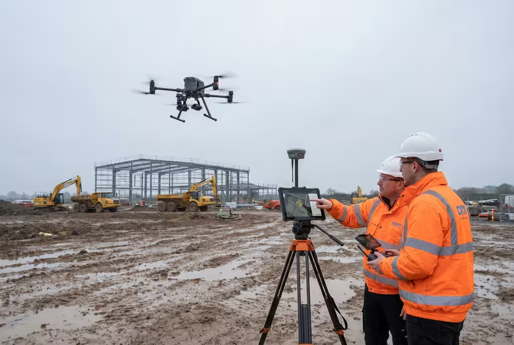
Drone thermal imaging employs radiometric thermal cameras mounted on professional UAVs to capture detailed temperature data across buildings, infrastructure, and landscapes. Unlike standard photography, thermal sensors detect infrared radiation emitted by surfaces, converting invisible heat patterns into colour-coded imagery that reveals temperature variations with precision.
At Hire Drone Pilot, our thermal drone platforms carry calibrated radiometric cameras measuring absolute temperatures across every pixel. This enables us to identify heat loss, moisture ingress, electrical faults, insulation deficiencies, and equipment anomalies invisible to the naked eye or conventional cameras.
Peter Leslie
Owner & Drone Pilot
"Have questions about thermal imaging? Ring me directly - I'm happy to discuss your project requirements."
Call NowReveal Hidden Heat Loss,Detect Problems Early
What You'll Receive
- Radiometric thermal imagery
- Temperature analysis report
- Annotated defect mapping
- Remediation recommendations
Delivered in 3-5 working days
Why Use HireDronePilot
- CAA certified & comprehensively insured
- Calibrated radiometric cameras
- Bookings within days
- Nationwide coverage
Relied upon by energy consultants, facilities managers & building surveyors throughout the UK.
Relied upon by major organisations
How Much Does Drone Thermal Imaging Cost?
Pricing depends on scale and complexity. Below is a guide to help with budgeting:
| Survey Type | Guide Price |
|---|---|
| Single BuildingResidential or small commercial | £350+ |
| Commercial / IndustrialMedium-scale facilities | £600+ |
| Large Site / Multi-BuildingEstates or portfolios | £1,000+ |
| Solar Farm InspectionPanel-level analysis | POA |
*Guide prices encompass standard deliverables. Final quotation depends on site complexity, building count, and specific requirements.
Factors Influencing Your Quote
- Building size & complexity
- Number of structures
- Site location & accessibility
- Time-of-day requirements
Drone thermal surveys typically cost 50-70% less than scaffolding-based thermographic inspections, whilst covering substantially larger areas in a fraction of the time. Share your project details and we will provide a tailored quotation within 24 hours.
Ready for a thermal imaging quotation?
Complimentary, no-commitment quotes within 24 hours
How Does Drone Thermal Imaging Compare to Handheld Methods?
Handheld thermal cameras require inspectors to physically access every surface, limiting coverage to ground-level or areas reachable by ladder. This approach is time-consuming, provides inconsistent viewing angles, and frequently misses upper facades, rooftops, and hard-to-reach zones.
Drone-mounted thermal cameras capture entire building envelopes from optimal vantage points in a single flight, ensuring uniform coverage, consistent calibration, and the ability to survey large sites rapidly without access equipment.
Why Select Drone Over Handheld?
Drone Thermal Survey
Complete coverage, rapid results
Handheld Thermal Survey
Ground-level access only
Uncertain whether drone thermal imaging suits your project?
What Can Thermal Imaging Detect?
Radiometric thermal cameras reveal issues invisible to conventional methods. Temperature anomalies indicate underlying problems long before they become visible:
- Heat loss & insulation defects – Pinpointing missing or moisture-damaged insulation within walls, roofs, and floors
- Moisture ingress – Detecting damp beneath roof membranes, within cavity walls, and around window reveals
- Electrical hotspots – Identifying overloaded circuits and deteriorating components in switchgear
- Solar panel defects – Locating hot cells, bypass diode failures, and string faults reducing output
- Air leakage paths – Revealing draughts around doors, windows, and service penetrations
Where is Drone Thermal Imaging Used?
Drone thermal imaging serves a broad range of industries and applications:
Building Diagnostics
Energy performance assessments, pre-purchase surveys, and planned maintenance inspections for residential and commercial properties.
Solar Panel Inspection
Cell-level defect detection across rooftop and ground-mounted arrays, identifying hotspots reducing energy generation.
Industrial Monitoring
Equipment condition monitoring, process vessel assessments, and pipeline leak detection across manufacturing and processing sites.
Electrical Infrastructure
Substation inspections, overhead line surveys, and transformer condition monitoring for utility companies and network operators.
Insurance & Claims
Documenting heat loss, moisture damage, and structural defects for insurance assessments and warranty claims.
Energy Audits
Supporting EPC assessments, retrofit planning, and net-zero carbon strategies with quantified thermal performance data.
Have a thermal imaging project in mind?
What Deliverables Do You Receive From Drone Thermal Imaging?
Our standard thermal imaging package includes:
Radiometric Thermal Imagery
Calibrated thermal photographs with embedded temperature data for every pixel, enabling precise measurement and analysis.
Annotated Defect Report
Professional PDF with thermal anomalies highlighted, categorised by severity, with corresponding visual photography for context.
Side-by-Side Visual Comparison
Matched thermal and RGB photographs enabling clear correlation between temperature anomalies and visible building features.
Remediation Recommendations
Practical guidance on addressing identified defects, prioritised by urgency and estimated impact on building performance.
Need specific deliverables for your project?
How Long Does a Thermal Survey Take?
On-site data capture is rapid: 30-45 minutes for residential properties, 1-2 hours for commercial buildings, and up to a full day for large industrial complexes. Surveys are conducted during early morning or evening when temperature differentials are greatest.
| Phase | Duration |
|---|---|
| Scheduling & Preparation | 1-3 days |
| On-Site Data Capture | 30 mins - 4 hrs |
| Thermal Analysis | 1-2 days |
| Report Compilation | 1-3 days |
| Overall (Standard) | 3-5 working days |
Rapid Service Available
Need faster turnaround? Same-day or next-day reports obtainable for time-sensitive projects.
How Do I Select a Thermal Imaging Provider?
Not every drone thermal imaging service delivers the same quality. When evaluating providers, examine these essential criteria:
- CAA certification – Valid GVC or legacy PfCO permissions for commercial drone operations
- Radiometric cameras – Calibrated radiometric thermal cameras, not consumer-grade sensors
- Thermography qualifications – ITC Level 1 or equivalent certification in infrared thermography
- Report quality – Request sample reports to assess depth of analysis and recommendations
- Insurance coverage – Public liability (minimum £1M) and professional indemnity protection
At Hire Drone Pilot, we satisfy every criterion listed above, holding full CAA certification and operating calibrated radiometric thermal cameras across the UK.
Ready to work with a specialist thermal imaging provider?
Best Conditions for Thermal Surveys
Optimal results require sufficient temperature differential between the heated interior and external surfaces. We schedule flights during the heating season (October to April) when differences are most pronounced.
Ideal Conditions
- Time of dayPre-dawn or evening
- Wind speedBelow 10 mph
- Dry for 24+ hoursRequired
- Temp. differential10°C+ indoor/outdoor
Conditions to Avoid
- Direct sunshineDistorts readings
- Heavy rainMasks anomalies
- Strong gustsCools surfaces
- Summer middayMinimal contrast
Ready to Reveal What's Hidden?
Specialist guidance • Tailored pricing • Avg Response within 5 Mins

Peter Leslie
Owner & Drone Pilot
With extensive experience in aerial thermography and building diagnostics, Peter personally oversees every thermal imaging project to ensure accurate, actionable results you can rely on.
Quick Guide: Drone Thermal Imaging Explained
Survey Deliverables
- Radiometric thermal imagery
- Annotated defect report
- Side-by-side visual comparison
- Temperature analysis data
- Remediation recommendations
- Executive summary
Talk Through Your Project
Obtain specialist guidance and tailored pricing.
Drone Pilot Reviews
Why Drone Pilots Rate HireDronePilot 5 Stars
Don't just take our word for it. Here's what drone pilots in our UK network say about getting work through the platform.
“I get relevant commercial briefs with clear scopes, so quoting is fast and accurate. It has helped me win consistent survey work without chasing low-quality leads.”
Adam Carter
Drone Pilot
“Since joining the platform, I have filled gaps in my schedule with quality roof and inspection jobs. The enquiry details are much better than generic lead forms.”
Sophie Bennett
Drone Pilot
“HireDronePilot makes it easier to focus on delivery. I can review project briefs quickly, submit competitive quotes, and pick up work in new regions.”
Daniel Khan
Drone Pilot
Complementary Services
Roof Inspection
Comprehensive drone roof assessments with optional thermal add-on for leak and moisture detection.
Facade Survey
Detailed building envelope inspections combining visual and thermal analysis of external walls.
Solar Panel Survey
Specialist thermal inspection of photovoltaic arrays to maximise energy generation performance.