Specialist Services
Drone Sonar Survey Services
Drone-deployed sonar technology maps underwater terrain, detects submerged objects, and profiles water body depths without the need for boats or divers. Rapid, safe, and cost-effective aquatic surveying across the UK.
Avg Response within 5 Mins • Or call +44 1334 804554
What is a Drone Sonar Survey?
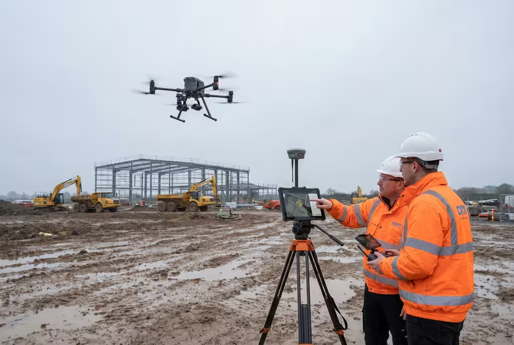
A drone sonar survey uses an unmanned aerial vehicle to deploy a tethered or droppable sonar transducer into water bodies, capturing detailed bathymetric (depth) data and underwater imagery. The drone positions the sonar module precisely across the water surface following pre-programmed survey lines, building a comprehensive map of the underwater terrain.
At Hire Drone Pilot, we deploy single-beam and multi-beam sonar systems carried by heavy-lift drones. This approach eliminates the need for survey boats, launches, and watercraft operators, making it ideal for remote, shallow, or hazardous water bodies where conventional boat-based surveys prove difficult or impossible.
Peter Leslie
Owner & Drone Pilot
"Have questions about sonar surveys? Ring me directly - I'm happy to discuss your project requirements."
Call NowMap What Lies Beneath,No Boats Required
What You'll Receive
- Bathymetric depth mapping
- Underwater contour plans
- Volume calculations
- Condition assessment report
Delivered in 5-7 working days
Why Use HireDronePilot
- CAA certified & comprehensively insured
- No boat or diver requirements
- Access remote water bodies
- Nationwide availability
Relied upon by water companies, environmental consultants & civil engineers throughout the UK.
Relied upon by major organisations
How Much Does a Drone Sonar Survey Cost?
Drone sonar survey pricing reflects the size and complexity of the water body and the level of detail required. Below is a guide to assist with budgeting:
| Survey Scale | Guide Price |
|---|---|
| Small Water BodyPonds, small lakes | £800+ |
| River / Canal SectionLinear water courses | £1,200+ |
| Large Lake / ReservoirMajor water bodies | £2,000+ |
| Monitoring ProgrammeRepeat surveys | POA |
*Guide prices encompass standard deliverables. Final quotation depends on water body dimensions, access conditions, and required survey density.
Factors Influencing Your Quote
- Water body size & depth
- Survey line spacing
- Access & launch conditions
- Volume calculation needs
Drone-deployed sonar eliminates the need for boat hire, launch facilities, and watercraft operators, typically reducing survey costs by 40-60% compared to traditional boat-based bathymetric surveys.
Ready for a sonar survey quotation?
Complimentary, no-commitment quotes within 24 hours
How Does Drone Sonar Compare to Boat-Based Methods?
Traditional bathymetric surveys require survey boats, trained crew, slipway or launch access, and often several days of mobilisation. For remote water bodies, transporting boats overland adds significant cost and logistical complexity. Shallow waters, weed growth, and restricted access can render boat surveys impossible.
Drone-deployed sonar requires only a clear area to launch the aircraft. The drone carries the sonar module to the water surface, follows precise survey lines at controlled speed, and returns data in real time. Water bodies that would require extensive boat logistics can be surveyed in hours with minimal equipment.
Why Select Drone Over Boat-Based?
Drone Sonar Survey
Rapid deployment, any water body
Boat-Based Sonar
Requires launch access & crew
Uncertain whether drone sonar suits your water body?
What Can Sonar Detect Underwater?
Drone-deployed sonar systems capture detailed information about underwater environments. The acoustic signals map the water body floor and detect objects, structures, and features beneath the surface:
- Bed topography – Detailed depth profiles and contour mapping of lake beds, river channels, and reservoir floors
- Silt and sediment accumulation – Measuring sediment depth to calculate storage capacity loss and plan dredging operations
- Submerged infrastructure – Locating underwater pipes, intake structures, dam faces, and outfall positions
- Obstructions and debris – Detecting fallen trees, dumped materials, rock formations, and navigation hazards
- Aquatic vegetation mapping – Identifying weed beds, invasive species distribution, and habitat features
- Erosion and scour patterns – Assessing bank erosion, bridge scour, and changes in channel morphology over time
Where Are Drone Sonar Surveys Used?
Drone sonar technology serves diverse industries and applications across the water management, environmental, and infrastructure sectors:
Reservoir Management
Storage capacity assessments, siltation monitoring, and dam safety inspections for water companies and reservoir owners.
Environmental Assessment
Aquatic habitat mapping, baseline surveys for development planning, and ecological impact assessments.
Infrastructure Inspection
Underwater inspection of bridge foundations, culvert outlets, weir structures, and submerged pipeline crossings.
Dredging Support
Pre-dredge volume calculations, progress monitoring during operations, and post-dredge verification surveys.
Flood Risk Assessment
River channel capacity modelling, floodplain mapping support, and natural flood management scheme design.
Quarry & Mining
Flooded quarry depth surveys, tailings pond assessments, and settlement lagoon volume calculations.
Have a water body requiring survey?
What Deliverables Do You Receive From a Drone Sonar Survey?
We tailor outputs to your project objectives, but our standard sonar survey package includes:
Bathymetric Depth Map
Colour-coded depth map showing the underwater terrain with contour lines at specified intervals, georeferenced to OS coordinates.
Cross-Section Profiles
Detailed cross-sectional views at specified locations showing bed profile, water depth, and channel geometry.
Volume Calculations
Accurate water body capacity calculations at specified levels, silt volume estimates, and comparative analysis against design profiles.
Interpretation Report
Professional report with findings summary, feature identification, condition assessment, and recommendations for maintenance or further investigation.
Need specific deliverables for your water body?
How Long Does a Sonar Survey Take?
On-site data capture with drone sonar is considerably faster than traditional boat-based methods. A small pond or lagoon can be surveyed in 2-3 hours. Medium water bodies require half a day. Large reservoirs may need 1-2 full days depending on the required survey density and complexity.
| Phase | Duration |
|---|---|
| Planning & Preparation | 2-5 days |
| On-Site Data Capture | 2 hrs - 2 days |
| Data Processing | 2-3 days |
| Report Compilation | 2-3 days |
| Overall (Standard) | 5-7 working days |
How Do I Select a Drone Sonar Survey Provider?
Drone sonar surveys require specialist equipment and hydrographic interpretation expertise. When evaluating providers, examine these essential criteria:
- Sonar equipment – Verify they operate survey-grade sonar systems with appropriate frequency and resolution for your targets
- Hydrographic experience – Ensure qualified personnel interpret and process the bathymetric data, not just pilots
- CAA certification – Confirm valid commercial drone permissions and insurance for operations over water
- Data accuracy – Ask about depth accuracy specifications and quality control procedures for survey data
- Relevant case studies – Request evidence of comparable water body surveys in similar environments
Ready to work with a specialist sonar survey provider?
Combined Above and Below Water Surveys
One of the most powerful advantages of drone-based survey technology is the ability to combine aerial topographic mapping with underwater bathymetric profiling in a single mobilisation. This creates a seamless dataset spanning the entire site, from surrounding terrain through the water margins and down to the bed of the water body.
Combined surveys prove particularly valuable for flood modelling, dam safety assessments, reservoir capacity studies, and environmental impact assessments where understanding the complete hydrological picture is essential.
Seamless Above-Below Water Data
Ask about combining aerial photogrammetry with sonar bathymetry for a complete site model at a reduced combined rate.
Ready to Map Your Water Body?
Specialist guidance • Tailored pricing • Avg Response within 5 Mins

Peter Leslie
Owner & Drone Pilot
With extensive experience in specialist aquatic surveys, Peter coordinates every sonar project to ensure accurate bathymetric data capture and professional interpretation you can rely on.
Quick Guide: Drone Sonar Surveys
Survey Deliverables
- Bathymetric depth map
- Cross-section profiles
- Volume calculations
- Georeferenced data layers
- Interpretation report
- CAD/GIS compatible files
Talk Through Your Project
Obtain specialist guidance and tailored pricing.
Drone Pilot Reviews
Why Drone Pilots Rate HireDronePilot 5 Stars
Don't just take our word for it. Here's what drone pilots in our UK network say about getting work through the platform.
“I get relevant commercial briefs with clear scopes, so quoting is fast and accurate. It has helped me win consistent survey work without chasing low-quality leads.”
Adam Carter
Drone Pilot
“Since joining the platform, I have filled gaps in my schedule with quality roof and inspection jobs. The enquiry details are much better than generic lead forms.”
Sophie Bennett
Drone Pilot
“HireDronePilot makes it easier to focus on delivery. I can review project briefs quickly, submit competitive quotes, and pick up work in new regions.”
Daniel Khan
Drone Pilot
Complementary Services
Water Quality Assessment
Aerial monitoring of water quality parameters including turbidity, algal blooms, and pollution indicators.
Coastal Survey
Shoreline mapping, erosion monitoring, and coastal change analysis using drone photogrammetry.
Environmental Survey
Comprehensive environmental monitoring and habitat mapping using specialist drone sensors.