Specialist Services
Drone Ground Penetrating Radar
UAV-mounted GPR technology reveals what lies beneath the surface without excavation. Detect buried utilities, voids, geological layers, and archaeological features across large areas rapidly and non-invasively.
Avg Response within 5 Mins • Or call +44 1334 804554
What is Drone Ground Penetrating Radar?
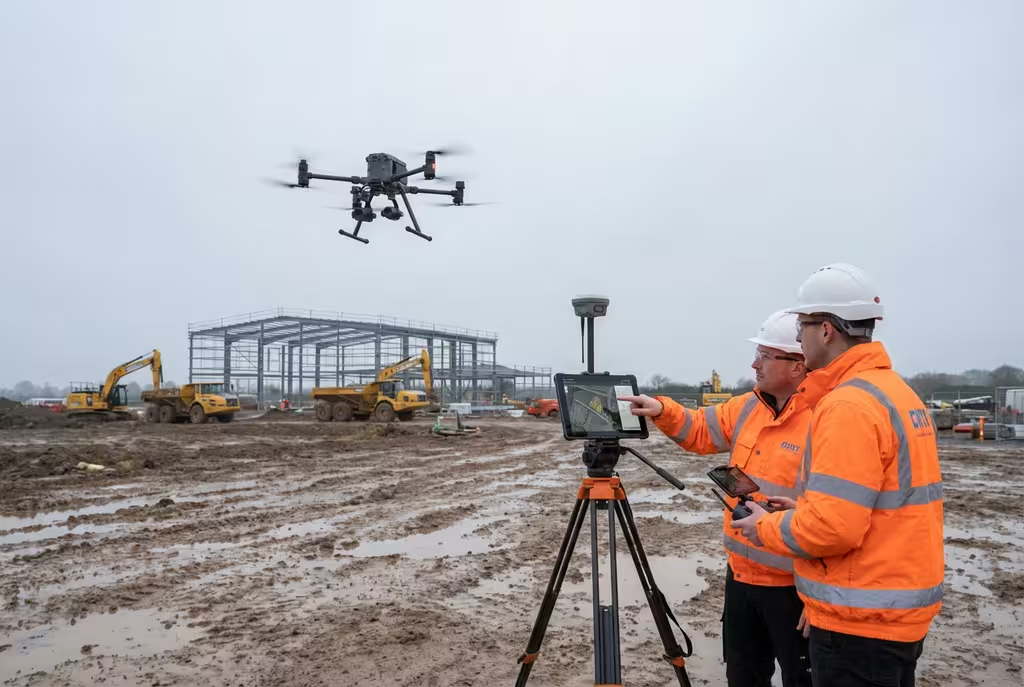
Drone ground penetrating radar (GPR) combines unmanned aerial vehicle technology with subsurface radar sensors to map what lies beneath the ground surface. The UAV-mounted GPR antenna transmits electromagnetic pulses into the ground and records the reflected signals, building a detailed cross-sectional profile of subsurface features.
At Hire Drone Pilot, we deploy drone GPR systems capable of detecting buried utilities, underground voids, geological stratification, archaeological remains, and structural anomalies. This non-invasive approach covers significantly larger areas than traditional hand-pushed GPR trolleys, making it ideal for extensive site investigations and preliminary ground assessments.
Peter Leslie
Owner & Drone Pilot
"Have questions about GPR surveys? Ring me directly - I'm happy to discuss your project requirements."
Call NowSee Below the Surface,Without Digging
What You'll Receive
- Subsurface profile mapping
- Utility detection report
- Georeferenced data layers
- Interpretation & recommendations
Delivered in 5-10 working days
Why Use HireDronePilot
- CAA certified & comprehensively insured
- Specialist GPR interpretation
- Large area coverage in hours
- Nationwide availability
Relied upon by civil engineers, archaeologists & utility companies throughout the UK.
Relied upon by major organisations
How Much Does Drone GPR Cost?
Drone GPR pricing depends principally on the survey area, required resolution, and depth of investigation. Below is a guide to assist with budgeting:
| Survey Scale | Guide Price |
|---|---|
| Small AreaUp to 0.5 hectares | £800+ |
| Medium Area0.5-2 hectares | £1,500+ |
| Large Area2+ hectares | £2,500+ |
| Linear CorridorRoutes & pipelines | POA |
*Guide prices encompass standard deliverables. Final quotation depends on terrain conditions, required resolution, and target depth.
Factors Influencing Your Quote
- Survey area & terrain type
- Required investigation depth
- Line spacing & resolution
- Ground conditions & access
Drone-mounted GPR covers ground 5-10 times faster than traditional hand-pushed systems, dramatically reducing survey costs for larger sites whilst maintaining comparable data quality.
Ready for a GPR survey quotation?
Complimentary, no-commitment quotes within 24 hours
How Does Drone GPR Compare to Ground-Based Methods?
Traditional ground-based GPR requires an operator to physically push or tow the antenna across the survey area at walking pace. This works well for small sites but becomes prohibitively slow and expensive for larger areas. Rough, waterlogged, or contaminated terrain can make ground-based surveys impractical or impossible.
Drone-mounted GPR flies the antenna at low altitude, covering vast areas rapidly regardless of ground conditions. The aerial platform maintains consistent survey speed, line spacing, and antenna height, producing more uniform data quality across the entire site.
Why Select Drone Over Ground-Based?
Drone GPR Survey
Rapid, terrain-independent
Ground-Based GPR
Walking pace, terrain-dependent
Uncertain whether drone GPR suits your site?
How Deep Can Drone GPR Detect?
Detection depth depends on several factors including antenna frequency, soil conditions, and the nature of the subsurface targets. In favourable conditions such as dry sandy or gravelly soils, drone GPR can penetrate to depths of 6-10 metres. In clay-rich or waterlogged ground, effective depth may be limited to 1-3 metres.
Lower frequency antennas achieve greater depth but with reduced resolution, whilst higher frequency antennas provide finer detail at shallower depths. We select the optimal antenna configuration for your specific investigation objectives and ground conditions.
Depth vs Resolution Trade-off
We will advise on the best antenna frequency for your targets and ground conditions during the planning stage.
Where is Drone GPR Used?
Drone ground penetrating radar serves diverse industries and applications where non-invasive subsurface information is essential:
Construction & Development
Pre-construction ground investigations, foundation design support, and buried obstruction detection before earthworks commence.
Utility Detection
Locating buried pipes, cables, and drainage systems across large development sites prior to excavation works.
Archaeological Investigation
Non-invasive detection of buried structures, ditches, foundations, and features prior to development or research excavation.
Geological Assessment
Mapping soil stratification, bedrock depth, peat boundaries, and geological anomalies for engineering and environmental projects.
Void & Cavity Detection
Identifying sinkholes, mine workings, tunnels, and subsurface voids that pose stability risks to structures and infrastructure.
Environmental Surveys
Mapping contamination plumes, landfill boundaries, buried waste deposits, and groundwater table positions.
Have a subsurface investigation requirement?
What Deliverables Do You Receive From Drone GPR?
We tailor outputs to your project requirements, but our standard GPR survey package includes:
GPR Profile Data
Processed radar cross-sections (radargrams) showing subsurface features, layer boundaries, and anomalies along each survey line.
Depth Slice Maps
Horizontal plan views at specified depths showing the spatial distribution of subsurface features across the survey area.
Interpretation Report
Professional report with annotated findings, feature identification, depth estimates, and recommendations for further investigation where appropriate.
Georeferenced Data
All survey data tied to precise GPS coordinates, enabling integration with CAD drawings, GIS systems, and site plans.
Need specific deliverables for your project?
How Long Does a GPR Survey Take?
On-site data capture with drone GPR is significantly faster than ground-based alternatives. A 0.5-hectare site can typically be surveyed in 2-3 hours. Larger sites of 2+ hectares may require a full day. Linear corridor surveys along pipeline or road routes proceed at approximately 1-2 kilometres per hour.
Data processing and interpretation require the most time, as specialist geophysicists analyse the radar profiles to identify and classify subsurface features. We provide clear timelines during the quotation process.
| Phase | Duration |
|---|---|
| Planning & Preparation | 2-5 days |
| On-Site Data Capture | 2 hrs - 2 days |
| Data Processing | 2-5 days |
| Interpretation & Reporting | 3-5 days |
| Overall (Standard) | 5-10 working days |
Expedited Service Available
Urgent project? Accelerated processing and reporting available for time-critical ground investigations.
How Do I Select a Drone GPR Provider?
Drone GPR surveys require both specialist flying skills and geophysical interpretation expertise. When evaluating providers, examine these essential criteria:
- Geophysical expertise – Ensure qualified geophysicists interpret the data, not just drone pilots capturing raw files
- Appropriate GPR equipment – Verify they operate drone-rated GPR antennas with suitable frequency range for your targets
- CAA certification – Confirm valid commercial drone permissions and appropriate insurance for your site environment
- Relevant experience – Request case studies from similar applications - utility detection, archaeology, or geological mapping
- Data deliverables – Confirm they provide interpreted results, not just raw radargrams requiring further specialist analysis
Ready to work with a specialist GPR survey provider?
What Can GPR Detect Underground?
Ground penetrating radar detects changes in the dielectric properties of subsurface materials. Any boundary between materials with different electromagnetic characteristics produces a reflected signal. The range of detectable features is extensive:
- Buried utilities – Metal and plastic pipes, cables, ducts, and drainage systems at various depths
- Underground voids – Sinkholes, mine workings, tunnels, cellars, and natural cavities posing collapse risk
- Archaeological remains – Foundations, walls, ditches, graves, and other buried structural features
- Geological boundaries – Soil layer interfaces, bedrock depth, water table position, and peat boundaries
- Buried tanks & objects – Fuel tanks, drums, concrete structures, and other man-made buried objects
- Contamination plumes – Changes in soil saturation indicating hydrocarbon or chemical contamination migration
Ready to See What's Below?
Specialist guidance • Tailored pricing • Avg Response within 5 Mins

Peter Leslie
Owner & Drone Pilot
With extensive experience in specialist drone surveys, Peter coordinates every GPR project to ensure thorough subsurface data capture and expert interpretation you can rely on.
Quick Guide: Drone GPR Explained
Survey Deliverables
- GPR profile data (radargrams)
- Depth slice maps
- Interpretation report
- Georeferenced data layers
- CAD/GIS compatible files
- Recommendations for further work
Talk Through Your Project
Obtain specialist guidance and tailored pricing.
Drone Pilot Reviews
Why Drone Pilots Rate HireDronePilot 5 Stars
Don't just take our word for it. Here's what drone pilots in our UK network say about getting work through the platform.
“I get relevant commercial briefs with clear scopes, so quoting is fast and accurate. It has helped me win consistent survey work without chasing low-quality leads.”
Adam Carter
Drone Pilot
“Since joining the platform, I have filled gaps in my schedule with quality roof and inspection jobs. The enquiry details are much better than generic lead forms.”
Sophie Bennett
Drone Pilot
“HireDronePilot makes it easier to focus on delivery. I can review project briefs quickly, submit competitive quotes, and pick up work in new regions.”
Daniel Khan
Drone Pilot
Complementary Services
Land Survey
Topographic drone surveys providing accurate elevation data and site plans for development projects.
Archaeological Survey
Aerial archaeological assessments combining photogrammetry, multispectral, and thermal sensors.
Environmental Survey
Comprehensive environmental monitoring and habitat mapping using specialist drone sensors.